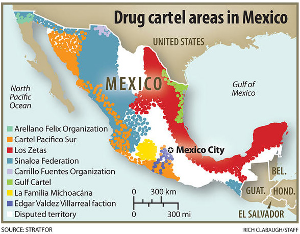
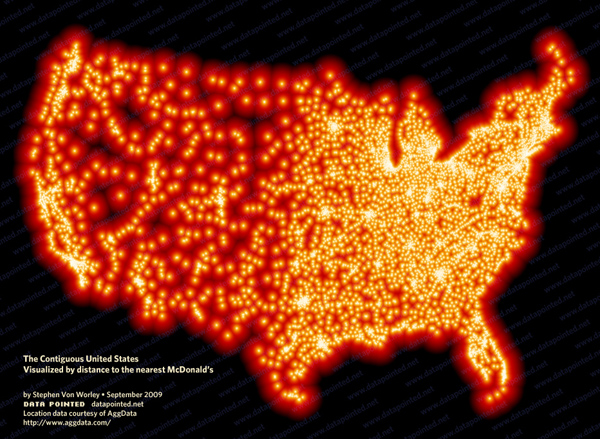
maps

What works

It’s a fun Friday post. Pull the slider to the right and watch the center of the US population move to the left (west) and south. What I like best about this is the interactivity. If it were just a static connect-the-dots it wouldn’t stay in your mind the way it does when you are the one doing the pulling of the slider. Getting those muscles involved, however minor their involvement might be, works more of your brain than if only your eyes were doing the work. My second favorite thing is more brain than brawn – the Census people found a way to remind us that in the beginning of our nation, we had fewer states. We added them as we went – almost always adding states to the west – so that can help explain why the center of the population originally started sliding leftwards. It has continued to slide leftwards (and towards the south) because those newer states have some lovely living conditions to offer. Not everyone loves the snow and ice of New England winters or the hurricanes of the southeastern seaboard.

What needs work

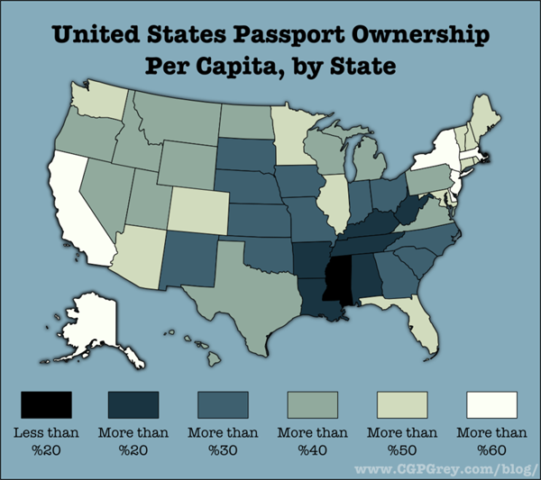
The center of population is a composite ‘score’ which tells us virtually nothing about why people are moving or where they are moving to…clearly, Missouri is not now a hotspot for internal migration. But if you were a school kid trying to grok the concept of the center of population, you might easily conclude that Missouri is a populous state.

I might have added some indicator of population sizes across US regions (state by state would be too confusing, but lumping by region would be fine).

References

2010 US Census. Center of Population

Drug Cartel Areas in Mexico | Christian Science Monitor

Drug cartels cause social ills

Unless you’ve had your head in a bucket since 2007, you are at least vaguely aware that Mexican drug cartels trafficking their goods into the US have caused significant social illness in Mexico, especially in areas close to the US border. Social illness here can be measured in cartel-driven murders, but that captures only the most gruesome, sensational branches of the drug virus. Besides the deaths are fear, anxiety, mistrustfulness as well as poverty, corruption, and vast inequality.

Is mapping the right way to understand Mexico’s drug trafficking problem?

The graphics here try to pack all of the complexity and destruction of those social ills into maps. Maps are rational. They allow us to feel we have a handle on the components that make up a problem. In this case, I am sure they are not explaining the whole story. I’m also not sure they are trying to explain the whole story.

What I like about the first map is that the map makers lay out the obvious: which cartels are where. Then they go one step further and highlight the contested territory. In case the colors aren’t coming through clearly, the white areas are the disputed areas. There are a lot of white areas.

And yet…

One would expect most of the violence in a situation like this to be in the disputed areas. But that isn’t the case. Most of the violence is near the US border. The border is another kind of contested territory, one that is much more important than white areas as far as violence prevention is concerned. In fact, those areas aren’t governed by one cartel or another because those areas are not critically important to drug trafficking. None of the cartels much care.

So let’s take a look at another map because I’m thinking the first one implies that we should find violence in the middle of the country.

Drugs and deaths in Mexico

Drug-related crimes south of the US border | The National Post

This graphic shows not only traffic patterns – where do the drugs go? – but also maps of where the deaths have been. It quickly becomes clear that the drug-related deaths are up near the US border, not in the ‘disputed areas’ highlighted in the previous map. In this map, (thanks unnamed National Post graphic designer) that undisputed area is left unclaimed and unlabeled. That’s a more accurate way to understand those regions and the inset series of maps below the main map do a good job of visually locating cartel-related violence.

The other thing I love about this map is that it specifies *which* drugs are being trafficked. Call me crazy, but I have found it odd that there is a great deal of talk about ‘drugs’ in Mexico as if there is no good reason to talk about which drugs are being moved where. Why is it useful to know which drugs are going where? First, it’s nice to know which drugs because different drugs have different price points per volume and weight. Economics matter. If one drug has a higher profit margin than another because it retails for more per ounce but doesn’t cost much more to produce/transport, one could assume that it will become more popular. Then again, demand matters, too. Even if pot is easy to produce, doesn’t mean you can convince cocaine users to try weed. They probably already tried it and moved on.

Another reason it matters which drugs we’re talking about is that detection and apprehension vary from drug to drug. An easy example: a pot sniffing dog probably won’t lead authorities to a stash of ephedra. What’s more, being able to tell where things are coming from and going to means that it is easier for authorities to target weak points in the routes. We know from news stories (I recommend looking at the LATimes, see references below), we know that drug runners pour much energy into protecting the drug routes right at the US border. But they aren’t digging tunnels under all of Mexico. There are points in the chain of drug traffic that are more vulnerable. Some of those points are deep within Mexico where it might be difficult to get well-trained, cooperative authorities with the necessary tools and manpower to perform raids.

My main gripe about these graphics is that they display this problem as a Mexican problem. This is not a Mexican problem. It is a Mexico-US problem. The demand in the US is pulling all those drugs up from south of the border. Looking at it this way helps introduce conversations about economic imbalances. I imagine that one of the reasons drugs come from Mexico is the same reason that many large companies choose not to have large labor forces in the US: labor is cheaper in Mexico. Various instantiations of poverty also tend to encourage corruption; encouraging local police to fight the cartels is hard when they are out-gunned and out-manned by cartels who can afford to pay off whoever they want including witnesses, other cops, border agents, and whoever else is likely to become cooperative after the application of a bit of grease.

Conclusion

The drug-related social illness in Mexico is an unfolding problem, one that has been discussed with more complexity elsewhere. I hope to illustrate that while the rationality of mapping patterns is appealing, it also tends to obscure complexity. It’s easier to misinform than inform with a map. They are deceivingly neat, these maps.

References

LATimes “Mexico Under Siege” special section, US News.

Llana, Sara Miller. (13 January 2011) “Mexico drug war death toll up 60 percent in 2010. Why?” in The Christian Science Monitor, World/Americas section.

National Post Staff. (31 December 2010) Graphic: Drug Terror Just South of the Mexico Border in The National Post. [Graphic].

Hidden-city airfares in the US

Excellent use of a map

I spend a lot of time explaining which uses of maps are bad. In this case, the use of a map is spot-on. Nothing could better display this information than a map. So here’s what you are seeing. Due to the mechanism that determines flight pricing, some non-stop flights from City A to City B are cheaper than multi-leg flights that take passengers from City A to City C with a layover in City B. Figuring out where these curiously expensive cities are and then booking tickets through them (instead of to them) is called hidden-city ticketing. It’s technically forbidden by the airlines because it messes up their profit-making abilities, more on that later.

There are some markets – Atlanta, Cleveland, Salt Lake City, Charlotte, Detroit, Cincinnati or Chicago O’Hare – where prices are too high compared to the rest of the airfare market. If you want the longer version of why this is true, there is an excellent, lengthy, FiveThirtyEight/Nate Silver blog post, Which Airports Have the Most Unfair Fares?, on the vagaries of airfare pricing. Suffice it to say, if you happen to need to fly into one of these expensive cities, especially if you do it often, you are interested in figuring out how to avoid feeling like you are getting ripped off.

As a visual representation of this simple-but-hard-to-explain Point A to Point C via Point B scenario, a map is the best way to clarify the concept. Just look at how the visual works. A person starts in Fargo and wants to get to Chicago. If they crank that request through kayak, they end up with a direct flight to Chicago for $586 [ouch]. But if, instead, they tell kayak that they want to go from Fargo to New York with a layover in Chicago they end up paying only $213. Kayak let’s you tell it where you’d like to have a layover. (Detroit’s airport is surprisingly nice, for instance, and if I have to layover in the summer, I’ll go through Detroit.)

How can airlines charge less to fly a person a greater distance? Not all airline pricing is driven by fuel, snacks, and human capital costs. A good bit of it is driven by demand and supply – the classic economics story from your undergrad days. Some markets are not well served creating mini-monopolies for service in and out of those airports. Other markets, like New York, have a great deal of service provision forcing airlines to pull their prices into a lower, more competitive range.

Is it legal?

Perhaps you have read somewhere in your ticket’s fine print that the airline prohibits you from bailing out of your scheduled travel halfway through the trip. The New York Times asked a lawyer whether or not it’s even legal for the airlines to penalize people this way and how far they can go to punish someone caught doing this. It turns out, there are penalties the airlines can impose, but most of them can be side-stepped by savvy travelers. The Times presented recommendations, summarized here:

Making a habit of this certainly won’t endear you to the airlines. Most of them — the major exception being free-spirited Southwest Airlines — expressly forbid it in their ticketing rules. But those rules don’t carry the force of law, and most travel lawyers say that their recourse is limited. They could probably preclude you from flying with them in the future, but their case for demanding penalties is weak, and the risk of detection is low if you don’t book these kinds of routes more often than a couple of times per carrier per year.

Also, do not end up checking bags. They will end up at your final destination. Get to the gate early enough to ensure yourself space in the overhead bins.

Book your itinerary as two one-way flights. This should be logically obvious. If you are going from Fargo to Chicago but you book your ticket through to New York, you clearly won’t be wanting a return flight from New York because you never intended to actually see the Big Apple in the first place. The other kicker is that if you fail to report for part of your ticket, the airline will probably cancel whatever remains on the ticket. So book one-ways.

Don’t lie if the airlines catch you; lying increases your likelihood of being found guilty of fraud. Honesty is the best policy.

References

Silver, Nate. (6 April 2011) Which Airports Have the Most Unfair Fares? [blog post] The New York Times, FiveThirtyEight blog.

Silver, Nate. (4 May 2011) How to beat high airfares. Sunday Times Magazine. [Graphic The Art of Hidden-City Ticketing]

Reading, Writing, and Earning Money | GOOD Transparency Blog

What works

Nothing is working for me with this graphic except possibly the few places where the designers offered detailed information about a particular location’s high school graduation ranking, college graduation ranking, and income ranking. But that’s being generous.

What needs work

Horrible use of a map. Maps should only be used where there is good reason to believe the information being conveyed is tied closely to geography. This information is not tied closely to geography though it might be tied closely to states. But states need not always be represented as geographical entities. Often, they are political entities and their particular geography is not salient.

The math that led to the graphic flattens important details and renders this a useless graphic. What I believe the designers did was something like this:

  • They took all of their numbers and turned them into some scale between 0 and 100%
  • Then they decided to represent each of the three variables with pure Cyan, Magenta, or Yellow. The higher the state scored on the scale from 0-100, the more saturated the color value.
  • Then they gave each county a combined score by building new colors from mixing the values of the previous three. Higher scoring states ended up with more saturated colors. Basically, higher scoring states started to approach black. States that scored high on just one vector ended up having a clearer, lighter color profile.

Here’s the big problem with this. It was hard for me to explain to my MIT-educated friend so I’m not sure this is going to make sense the first time ’round. Representing everything on a scale from 0-100 is a slide towards obfuscation. The graduation rates are both unadulterated rates. The income data represents un-scaled median incomes. I appreciate that they are not scaled, but I have a hard time adding 65% with $45,000. That’s some troubled math. At least in the monochrome maps we know what we’re looking at before the three variables get added up.

A grave sin was committed when the numbers for these three different variables were added up. Now, of course, it wasn’t the numbers that were added up. It was the color values of each of the three separate data points that were added up. Additive color seems to be something that does not send up a red flag. I can guarantee you that if they had presented something – a table or graph – where they had ended up adding values from high school graduation, college graduation, and income, red flags would have been flying. Why? Well, maybe you’re starting to catch my drift, but I’ll help you by spelling it out. What happens when the colors are added is a clear violation of the ‘apples to apples’ rule. Comparisons do not work unless you are sure you are comparing like things. Graduation rates are not like income. They are two different kinds of numbers – one is a rate the other is either a linear value or a log-linear value. Either way, they cannot be added up and still make sense. It’s no surprise that the graphic ends up looking like an incomprehensible slurry of a gray area.

References

GOOD and Gregory Hubacek. (March 2011) Reading, Writing, and Earning Money in GOOD Transparency Blog.

http://www.datapointed.net/

Data Pointed

I experienced the vastness of the internet today, stumbling across Data Pointed which is a not-new blog featuring original data visualizations. Why haven’t I come across it before? I wish I knew the answer to that as well as to the related question: how many other interesting data visualizations sites are out there that I do not know about?

What you see above is the most recent post at Data Pointed by Stephen Von Worley. He produces sophisticated graphics across a wide array of subject areas. Just so happens that this one is about the inter-relationship of the income distribution and the tax distribution which is of keen interest to social scientists, and policy people in particular. I find this visualization to be beautiful looking but a little hard to read. Each year is represented by a line, that line is drawn through all of the income brackets you see along the x-axis. As the line passes through these income brackets it changes both color and thickness. Thick red lines indicate areas in which people are paying more than their share of taxes; thin blue lines are areas in which people are paying less than their share of taxes. Von Worley had this to say:

“A modified Reagan-era tax system lingers to this day. To his credit, Dubya did reduce taxes on very low earners, so they’re no longer getting hammered. But, the people at our economy’s core – the full-time workers earning between $20,000 and $150,000 a year – still pay at up to double the rate of the ultra-wealthy, relative to what history suggests they should.”

Personally, I had a hard time drawing that message out of the graphic, despite the fact that it is so beautiful and elegant that I was compelled to stare at it and read the explanation until I could figure out how it worked.

McDonald’s Distances in the US

Von Worley himself notes that Data Visualization was not the popular success he had hoped, at least not at first. [Note: Graphic Sociology isn’t exactly a success in terms of page traffic, but it has a core of steady followers generating a four-digit count of unique page views per week.] Data Visualization got popular after Von Worley created the map graphic below that uses blobbiness to indicate distances between points on the US map and the nearest McDonald’s. The farthest you can get from a McDonald’s in the US is 107 miles and you would be in South Dakota.

Distance to nearest McDonald's in the US | Stephen Von Worley

Does the map work?

I am not entirely sure the map is working – again, it is beautiful. Beautiful is compelling and being compelled, I wanted to spend time looking at it. I also love that it kind of looks like fat globules. How appropriate and subtly political. We also end up with a very good proxy for American population density. Not bad. But what would have been even more awesome is if we could tell this was a distance map without having to read the caption. I want to know that there’s a McD’s at the center of each blob and that what I’m supposed to notice is the distance I need to go to get from the darkness to the light. (In my version, I might have had the centers of the blobs be dark and the peripheries be light but I’m guessing it wouldn’t read as well visually no matter how well it fits with my understanding of McD’s as a morally shady place.)

References

Stephen Von Worley (15 March 2011) Shifting Burdens: U.S. Taxes By Income Level Over The Years at Data Pointed Blog.

Percentage of US citizens holding passports, by state
Percentage of US citizens holding passports, by state | Andrew Sullivan

Passport background

In 2008 as part of the war against terror, US citizens were required to have a passport to travel to countries like Canada and Mexico that had previously allowed passport-free travel. US citizens could drive or walk into Canada and Mexico with a driver’s license and be allowed to drive or walk right back in. In 2011, we see from this map that even now, not all US citizens have passports, not even close. Getting a passport is time consuming, costly, and generally requires some evidence that the person applying for the passport intends to travel outside the US. That last requirement is kind of a no-brainer, why would anyone want to go through the effort to obtain a passport if they never planned to leave the US?

What works

Always skeptical about mapping data that could appear in a table or chart, I have decided that I’m neutral on this particular use of mapping as a presentation device. If the map had included Canada and Mexico rather than just making the US appear to float in space, I would probably have been more convinced that the map was the way to proceed with this information. If I had created a chart or a table, I would have divided the US states into two groups: those that border foreign countries and those that do not. Have a glance at the map again and you will see that the states bordering foreign countries have higher percentages of passport holders, on average, than those states that do not border foreign countries. Florida and Illinois do not border foreign countries and yet they both have high percentages of passport holders. In the Florida case, I would say it’s almost as if Florida borders foreign countries since so many of its near neighbors are island nations – Haiti, the British Virgin Islands, the Dominican Republic, and so forth.

Illinois is home to Chicago, a destination for immigrants and immigrants often leave family in other countries whom they would like to visit. Thus, they will need passports. The same is true for most big cities – New York and California (home to New York City and Los Angeles) also have large immigrant populations and large numbers of passport holders. On the other hand, Saskia Sassen might point out that what’s going on in Chicago, LA, and New York is that all of these cities are global cities, hubs of activity in Finance, Insurance and Real Estate (FIRE industries). These FIRE industries are global industries and require their workers to travel internationally at higher rates than the same kinds of workers in other industries.

It would be interesting to compare the rates of passport holders to both the rates of first generation immigrants and the proportion of workers in the FIRE industries in all these states.

What needs work

As I mentioned, presenting this information as a map begs to have Canada and Mexico included. In order to visualize the story here, it would be helpful to see what is happening at the borders, to remind ourselves that the US does not simply float in space. It is geographically specific and it matters that some states have international borders and others do not. Sometimes these borders ARE the story and I think when we’re talking about passport holders, the borders are important.

If this information were to be presented as a set of bar graphs, we would risk some information overload since there would be 50 bars. But that might be alright if it became instantly visually clear that the border states have higher rates of passport holdership than the interior and non-bordering states. Plus, with a bar graph, the numbers could have been layered on each bar (and really, they could have been layered on each state in the map) so that we would be able to get a more precise calculation. Simply knowing that we are working with some number in a 10% range is kind of sloppy for my tastes. That’s just me. And sometimes with information like this it’s silly to try to get granular because the data collection method could have a fairly wide margin of error. Though I should hope that the feds know who is holding passports. I suppose people could apply for them in one state and then move to another state. The feds may not know about moves following passport application and that could introduce some fuzziness.

Note: I tried to go to the original source of the map several times but the page timed out repeatedly. Therefore, I ended up citing Andrew Sullivan at the Atlantic since that is where I encountered the map and it is a website that I believe you can visit whereas cgpgrey.com/blog is not visit-able. If I had been able to visit I might have been able to figure out where the passport data came from in the first place – presumably some federal department.

References

Sullivan, Andrew. (8 March 2011) Map of the Day: How many Americans have a passport, by state in The Daily Dish at The Atlantic online. [Graphic by cgpgrey.com/blog]

Sassen, Saskia. (2001 [1991]) The Global City: New York, London, Tokyo, 2nd ed. Princeton, New Jersey: Princeton University Press.

Meta Infographic | Think Brilliant

What works

Using an infographic to deconstruct and critique trends in infographic design is a bit more clever than what I do – using text to deconstruct and critique infographics – though I still think there is good reason to do what I’m doing.

Even though Think Brilliant does a good job of spelling out some of tropes of information design that often populate information graphics, they leave some of these pesky problems obvious-yet-unarticulated. In particular, I love the way they split the word DIAGRAMS in odd places so that it would conform to the shape of the text box it inhabits. I very much dislike that sort of trick. The text need not conform so tightly to its text box that it stops looking like a word and starts looking like an advertisement for the typeface.

Click through on the image or the caption and read it over yourself. Notice that Think Brilliant agrees with me about maps – they get used at times when it seems as though there is barely any geographical information being displayed. Sure, cities exist somewhere in the global geography, but if the viewer is supposed to be comparing one city to the next, it is usually far easier to do that using a graph, table, or chart than a map. If you want to tell me about the weather, go ahead and use a map. But if there is no good reason to use a map rather than a chart or table, using that map often dilutes the message by implying that geography is the primary element determining the quantities in question when it is rarely the case that geography is primary.

I also dislike 3D graphs because they make it harder for the eye to connect the bar back to the axis in for purposes of interpretation. And even though it often seems that infographics have the number one purpose of being pretty, in fact, their number one purpose is to make complicated multi-variable situations easier to interpret.

Well done, Think Brilliant.

Friday afternoon thoughts about infographics vs. writing

Writing about something generally requires a linear interpretation because it is nearly impossible to read two things at the same time and it isn’t all that easy to read something that does not have a singular flow. I guess one could read unordered, bulleted lists…but that’s tedious and inelegant. Making an infographic does not require linearity. It does require just as much thought and craft as writing. Where the story is mostly linear, by all means do us all a favor and write about it. Unless you cannot write and then you are welcome to try your hand at infographic creation (ahem, NYU undergrads, that bit about not being able to write well includes more of you than you think).

In the best of all possible worlds, graphics will be used alongside writing in order to offer readers/viewers multiple ways to understand and engage with your work. Social scientists generally present multi-layered research findings based on sometimes complex sets of assumptions. Asking the reader to get with the program and hold all those moving parts in mind at once can be a lot to ask. For all we know, the reader has not consumed anywhere near the amount of caffeine that they need to operate at peak efficiency. Help the reader. Tell the same story with your words, graphics, and images. This goes for both qualitative and quantitative methods. Just because a project is based on interview and ethnographic data does not mean it is impossible to make graphics or acceptable to skip their inclusion in your work.

As you can see from the graphic above, people can see through designerly gimmicks. Folks want meaningful information in their graphics. Better to create a simple infographic that risks being a bit plain than to skip creating a graphic (or to turn a simple graphic into something that makes ridiculous use of 3D, color, maps, typeface, layout, or any other graphic design trope applied without any value-add in the meaning department).

Human Development Index Map
Massachusetts Human Development Index

What works

Mapping the Measure of America is a social science project that deliberately includes information graphics as a communication mechanism. In fact, it is the primary tool for communicating if we assume that more people will visit the (free) website than buy the book. And even the book is quite infographic dependent. I support this turn towards the visual. I also support the idea that they hired a graphic designer to work with them. Often, social scientists do not do well when left to their own under-developed graphic design skill set. Fair enough.

The website presents a unified view of the three images above. I couldn’t get them to fit in the 600 pixel width format, so I presented them one at a time. I encourage you to go to the website because one of the greatest strengths of this approach is the interactivity and layering. I happen to have picked Massachusetts, but each state plus DC has it’s own graphics available. There are other charts and whatnot available, but I think that this set of graphics (which you see all at once) are the strongest.

What needs work

Maps. Maps are too often used. Here’s why I think maps are a problem. Look, folks, political boundaries are meaningful when it comes to making policy or otherwise dealing with state-based funding. And that’s about it. Political boundaries occasionally coincide with geographical boundaries, but not always. Geographical boundaries are meaningful for some things – life opportunities may be based on natural resources or on historical benefits accruing to natural resources. But political boundaries and maps are often not all that useful because they imply that the key divisions are the divisions between states or counties or neighborhoods. Like I said, sometimes this is true because funding tends to be like the paint bucket tool – it flows right up to the boundaries and not beyond, even if the boundaries are arbitrary or oddly shaped. But where the issues are not heavily dependent on funding, thinking in terms of political boundaries makes it harder to see patterns that are organized along other axes. For instance, I wonder what would have happened if some of these categories – education, longevity, income – had been split between urban, suburban, and rural areas. Or urban and ex-urban areas if you prefer that perspective on the world as we know it.

In the end, I think the title is both accurate and disappointing: “Mapping the Measure of America”. Figuring out how to do information graphics well means figuring out which variables are the key variables. In this case, it seems that the graphic options might have determined the display of the information. Maps are easy enough – they appear to offer a comparison between my local and other people’s local. Those kinds of comparisons offer readers an easy way to access the information because everyone is from somewhere and there is a tendency to want to compare self to others. But ask yourself this: to what degree do you feel that state-level information is a reflection of yourself? Do you see yourself in your state?

References

Burd-Sharps, Sarah and Lewis, Kristen. (2010) Mapping the Measure of America with the American Human Development Project. Site design credit goes to Rosten Woo and Zachary Watson.

Clothing and Footwear, Global Spending 2007

Electronics, Global Spending 2007

Recreation, Global Spending 2007

What Works

I have been thinking about other ways to work with maps lately, and I stumbled upon this interactive consumption map created by the folks at the New York Times using numbers from Euromonitor International, 2007. This graph was certainly a product of a moment in time – I don’t see too many people making consumption graphs like this one these days. They might be making line graphs where the total amount of consumer spending or consumer confidence is of immense concern to finance people who are eager for the next growth period in the economy. (I’m not saying that only finance people are looking forward to economic growth, just suggesting that they are the people who spend a lot of time studying consumer behavior as they anticipate the growth period. The rest of us might be looking at our own retirement statements or home values or paychecks.)

This map approach to spending is great because the graphic designers – Hannah Fairfield, Elaine He and Kevin Quealy – realized that maps are just schematics. It isn’t necessary to stick with a country’s shape, but it is nice to keep them in about the same positions relative to one another. Freeing each country from the shape of its political boundaries allows each square country to change dimensions in direct relation to total consumer spending within a sector. The color tells us what this works out to in terms of per capita spending. If you clicked through to look at the actual interactive graphics you’ll find that if you mouse-over a country, you can see the dollar amount of the total spending for whatever sector you happen to be viewing.

The strength of this graphic is that it strips away unnecessary detail to focus your eye’s attention on the most salient information in an easy-to-digest kind of way. This is a huge improvement over the sort of thing that I see all too often (and have included a little global poverty example here). My eye is terrible at assessing relative areas when the shapes are so irregular like this. Much better to just keep the relative positions of the countries and give them square shapes that can be quickly, effortlessly scanned for the sake of comparison.

Human Poverty
Human Poverty

What needs work

I would have put the per capita spending in the roll-over as well. Right now it’s just the country’s total spending. I also would have thought about a way to represent all the countries that don’t even make this map. Something understated and subtle – a sprinkling of grey dots? But then those countries might look like dust…still thinking about that.

The other thing I might have liked would be to have either gone completely grey scale (preferred) or to have selected a single color for each sector with increasing saturation as spending increases. The second approach would have made more sense if the product was a series of print graphics, but the approach they actually took and the grayscale approach are better for this sort of interactive graphic in which the viewer sees only one at a time.

References

Hannah Fairfield, Elaine He and Kevin Quealy. (4 Sep 2008) “What your global neighbors are buying”. Business Section of the New York Times. Using Euromonitor International figures.

Fairfield, Hannah. (4 Sep 2008) Guccis or Gadgets? Business Section of the New York Times. [related article that ran with the graphic]

Xanax Nation | GOOD Mag. Transparency Blog

What works

Um, so, I’m trying to think of what is working here. I guess we see that there are about 10 psychiatric drugs, that lots of people appear to be receiving treatment for anxiety (heck, two wars, an economic crisis, trapped Chilean miners, BP’s oil spill…all this anxiety makes sense to me). We are meant to believe that this represents a huge and possibly stifling example of big pharma. But really, this graphic doesn’t say that to me. It says “lots of people are anxious and choosing to take prescription drugs to cope”.

Xanax Nation without the map

What needs work

Just for some crazy antic fun, infographic style, I whipped out my digital crop tool and got rid of the map just to see what we would lose. Clearly, we lose some fun. Almost all the pretty colors are gone. But the information? It’s all still there. The map was being used as a giant and rather useless crutch in this case. This is a particularly egregious case, but there are many instances of maps that don’t encode any information that is useful for the debate of the topic at hand. Ask yourself: what did the map do? Was there any variation contained in the map? Was the dataset in question geographically oriented in any way? No. No, it was not.

Thanks to Austin Haney, Sociology grad student at Kent State for sending this our way.

References

Drugged Culture GOOD magazine, Transparency Blog.

(2010) One Nation Under Xanax in Psychiatric Times.