poverty

US food security map | Gallup via Marketplace.org

What works

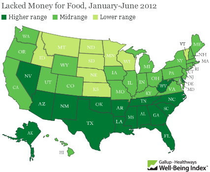
Food insecurity – worrying about having enough money to buy food – is an extremely important problem. Gallup came up with new poll numbers on the prevalence of food insecurity in the US just this week and spokesman Frank Newport did an interview on the findings with Tess Vigeland of the radio show Marketplace. Marketplace ran the map graphic above on their website which is somewhat rare for a radio program given that graphics just do not have much of a place on the radio.

The survey question was:

Has there been one time in the last 12 months when you did not have enough money to buy the food that you or your family need? And overall, 18 percent of Americans so far this year — the first half of the year — said yes, there has been at least one time.

The graphic makes clear that the problem of food insecurity has a north-south pattern to it. People in the South have “high” levels of reporting food insecurity while people in the middle and on the west coast have “moderate” levels of food insecurity and folks in the north have “low” levels of food insecurity. But…

What needs work

…where are the numbers? What ranges are represented by the “low”, “medium”, and “high” levels of reported food insecurity? This information should be in the graphic. Legends matter.

What we can imply from the interview is that the states in the “high” range have 20% of their poll respondents reporting that they’ve had trouble paying for the food they need in the last 12 months. The “low” level of insecurity includes states like North Dakota where 10% of people reported having trouble paying for food. That still seems high given how wealthy Americans are on the whole. This food insecurity data is one way to think about just how economic inequality plays out in the US. Folks cannot even afford the food they need.

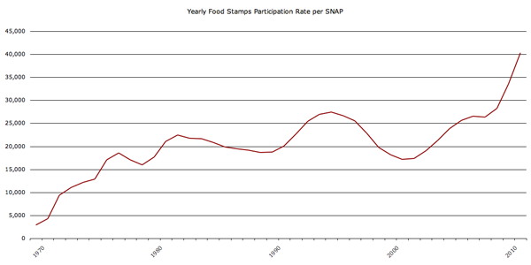
Here’s another graphic to think about, the rate of the use of food stamps (SNAP):

Food stamp program participation 1970-2010
Food Stamp program participation 1970-2010

Understanding food insecurity is one of those things that is going to require more than a single map based on a single survey question asked at one point in time. Well-designed graphics can and should aim to depict complexity and nuance…kind of like any other representation of critical analysis (writing, reporting, etc).

References

Vigeland, Tess. (23 August 2012) Americans struggle to feed their families. [Interview with Frank Newport] marketplace.org

Global charitable giving

Global charitable giving map, 2011
Global charitable giving map, 2011 | Charities Aid Foundation

How much do people give?

Globally, there are some major differences in giving rates on a national basis. The Charitable Aid Foundation conducts and annual global poll that asks about giving money, giving time, and helping individual strangers. The 2011 report notes that when it comes to predicting which countries have the most generous citizens:

The countries whose populations are the most likely to give are not necessarily the world’s most affluent. Only five of the countries that feature in the World Bank’s top 20 by GDP (PPP) per capita feature in CAF’s World Giving Index top 20.

World Giving Index by World Region
World Giving Index by World Region, Charities Aid Foundation

The US moved from 5th place in 2010 to 1st place in 2011 with increases in the number of people donating time, money, and aid to individual strangers. I guess we respond to the economic crisis by donating to specific people and causes while demanding lower taxes? Anyone else want to try to interpret that?

As for the graphic, I wish there were a key. I figured out eventually that the number inside the circle represents the country’s overall rank and that the size of the circle is proportional to per capita giving. I had to look at the graphic for a while to convince myself that the size of the circles was proportional to per capita rather than total giving per country. The one thing I like most is the inclusion of the small inset map in the upper right corner that helps relate the circles back to the map of the world that we are used to seeing.

But let’s take a look at giving in the US, since we are supposedly the top of the heap as of 2011.

US charitable giving

Charitable giving in the US by region, 2000

How much do Americans give?

Caveat: I was not able to find US data from 2011 so the bottom half of this blog and the top half are out of sync temporally. Also, the US study only looked at cash donations whereas the global index looks at donations of cash and time as well as helping behavior towards individual strangers.

Individual giving in America is divided between two general categories of giving – religious and secular. Many church members give cash and write checks to their churches either as part of tithing or in less formal donations to the offering plate when they get around to attending a service. Measures of religiosity in the US indicate that Americans are slowly becoming less religious over time. A WIN-Gallop poll of global religiosity came out on July 27th and showed that only 60% of Americans are regular churchgoers, down from 73% seven years ago. I wondered how that would impact charitable giving here in the US. Unfortunately, the only free data I could find was from 2000 which is well before the findings from the recent poll data. [Note: If you are extremely interested in charitable giving in the US there are quite a few reports available to those willing to pony up some cash at Giving USA.]

The table above is a summary of the state-level, individual cash donation activity of Americans in 2000 that was originally constructed by John Havens and Paul Schervish at Boston College’s Center on Wealth and Philanthropy. They used a slightly different methodology from the one used by the aforementioned Giving USA group that I found more compelling. Giving USA was looking at cash giving by examining the itemized deductions folks list on their annual income tax forms. However, many people (especially lower income people) do not itemize their deductions. Further complicating matters at the state level is the fact that some states have many more itemizers than others. Therefore, looking at itemizers in one state is very different than looking at itemizers in another state. In one state we might only capture fairly wealthy people. In other state, we might be looking at a much broader cross section of the population. Havens and Schervish not only tried to make sure they had comparable samples of people from each state, they also took into account costs of living in different states and weighted their totals based on the number of households in each state.

I summarized their major findings above. What frustrated my data visualization self the most was that I could not make a similar cartograph that would allow us to see the US the way we can see the globe in the cartograph at the top. Havens and Schervish pooled data for a number of states together – see where I have tried to list all the states in each of the regions? See how it says ‘Other States’ four different times? The explanation for this was that the sample size in some states was so small it had to be pooled in order to maintain the subjects’ anonymity. Fair enough. I just wish it were otherwise.

Are states within the same region similar when it comes to charitable giving? For the most part, no.

The midwest has no major outliers, high or low (at least, not that I can tell given that some states are lumped into that obscure “other states” category). The other three regions show wider dispersion. The west, for example, has the most generous state (Utah: $2632) but just next door is Nevada with a very low rate of giving (Nevada: $303). The south looks fairly generous on average, but that average obscures some dramatic differences. Two states pull up the average (Alabama: $1842 and South Carolina: $1243) and make up for the two of the least generous states which are also in the South (Kentucky: $218 and the District of Columbia: $273). With respect to DC, my hunch is that wealthy lawmakers and other multi-state residents buzzing around DC may be reporting all of their charitable giving on their tax forms for their “home” states. I cannot explain why Kentucky gives so little. Another notable miser of a state is New Hampshire (New Hampshire: $246). Shall we take a moment to ponder the implications of the “live free or die” ideology?

References

Charities Aid Foundation. (2011) World Giving Index [information graphic] Kent, UK.

Charities Aid Foundation. (2011) World Giving Index 2011. [Report]. Kent, UK.

Havens, John and Schervish, Paul. (2005, November) Geography and Generosity: Boston and Beyond [report] Boston: Center on Wealth and Philanthropy at Boston College. For convenience, I extracted the relevant table for download <a href="generosity-report-extract“>here.

Human Development Index plotted against Electricity Consumption

What works

Infrastructure is a critical resource for supporting basic human life and this graphic does a good job of indicating the geometrical returns to electrical infrastructure in poor places. A little bit of electricity goes a long way.

Electricity doesn’t cause well-­being, of course. But it is a powerful enabler. When people have lights that allow them to study and work after dark, refrigeration to keep foods and medicine fresh, pumps and purifiers to irrigate farmland and produce safe drinking water, and cell phones and computers to connect them with commercial, educational, and health care resources, they can more fully participate in the social and economic activities that drive human development.–Arun Majumdar

What needs work

The Human Development Index should be spelled out a little in graphics like this until it is clear that the average person on the street knows what is represented by the Human Development Index. [To the author’s credit, he does outline the components of the HDI in the text.] It can be a very tricky metric. The Human Development Index used by the UN uses four measures: life expectancy at birth, mean years of schooling, expected years of schooling, and gross national income per capita to create the human development index for a country. They use two measures of education so that they can be more sensitive to changes as they happen. It takes a long time to change the mean educational attainment in a country even if that country has recently put in place policies and infrastructure to educate more children for a longer period of time. All of the measures are chosen because they are relatively easy to measure and because most countries have at least sort of reliable data for all four measures.

Human development index - UNDP

I also don’t like that all of the wealthier countries are labeled but only some of the poor countries in the lower left are labeled.

I assume the colors refer to continents. A key would have helped.

To help viewers understand kilowatt hours, I would have liked to see some comparison between something a typical person would be familiar with and this magical 2500 kilowatt hour/person/year threshold. How many days could I power my iMac at that rate? A month? Half a year? What about my refrigerator? I have no idea how much 2500 kilowatt hours might be.

References

Majumdar, Arun. (2012) Electrifying the bottom of the pyramid Harvard Business Review.

UNDP. (2011) Human Development Index.

Food Price Mashup | Mark Bittman

What works

After looking at this graphic, I imagine most viewers come away thinking that fast food is more expensive than cooking at home, which was the intention of the accompanying opinion piece by Mark Bittman. The graphic succeeds in conveying visually just exactly the point that the article made using words.

The photographs are vibrant and catchy, bordering on food porn.

The sidebars feature the calorie counts for these meals in addition to the large price tags. The nutritional information graphs are useful for Bittman’s response to existing critics of the ‘cooking at home is better’ movement who have tried to argue that though fast food may be more expensive on a per meal basis, it is actually cheaper on a per calorie basis because fast food is so calorie dense (if a bit too heavily reliant on nutritionally vacuous fats and sugars). Bittman uses the nutritional information graphs to refute this claim and I applaud the graphic designer for including the rebuff of the critics in the graphic. It would have been easy enough to simply run the photos of the meals with their price tags.

What needs work

The photos take up too much space. This almost looks like an advertisement for McDonald’s, chicken, and beans.

The nutritional information bar graphs are potentially confusing. They do not measure absolutes so much as they show how each of the home-cooked meals stack up against McDonald’s. Since people are not used to thinking of their meals in comparison to what they would have eaten had they eaten at McDonald’s, I’m not sure the comparative nutritional graphs work as well as one graph that used absolute data and had all three meals on it. I am almost positive the graphic designer probably tried making just exactly that graph – if they are out there reading this I invite them to send me what that looked like to prove that my hunch to use a unified graph on this one would have been ugly, confusing, or just plain wrong.

References

Bittman, Mark. (24 September 2011) Is Junk Food Really Cheaper? New York Times, Sunday Review. Op-ed column.

Bittman, Mark. (20 September 2011) Cooking Solves Everything: How Time in the Kitchen Can Save Your Health, Your Budget, and Even the Planet [e-book] published by Byliner.

http://www.datapointed.net/

Data Pointed

I experienced the vastness of the internet today, stumbling across Data Pointed which is a not-new blog featuring original data visualizations. Why haven’t I come across it before? I wish I knew the answer to that as well as to the related question: how many other interesting data visualizations sites are out there that I do not know about?

What you see above is the most recent post at Data Pointed by Stephen Von Worley. He produces sophisticated graphics across a wide array of subject areas. Just so happens that this one is about the inter-relationship of the income distribution and the tax distribution which is of keen interest to social scientists, and policy people in particular. I find this visualization to be beautiful looking but a little hard to read. Each year is represented by a line, that line is drawn through all of the income brackets you see along the x-axis. As the line passes through these income brackets it changes both color and thickness. Thick red lines indicate areas in which people are paying more than their share of taxes; thin blue lines are areas in which people are paying less than their share of taxes. Von Worley had this to say:

“A modified Reagan-era tax system lingers to this day. To his credit, Dubya did reduce taxes on very low earners, so they’re no longer getting hammered. But, the people at our economy’s core – the full-time workers earning between $20,000 and $150,000 a year – still pay at up to double the rate of the ultra-wealthy, relative to what history suggests they should.”

Personally, I had a hard time drawing that message out of the graphic, despite the fact that it is so beautiful and elegant that I was compelled to stare at it and read the explanation until I could figure out how it worked.

McDonald’s Distances in the US

Von Worley himself notes that Data Visualization was not the popular success he had hoped, at least not at first. [Note: Graphic Sociology isn’t exactly a success in terms of page traffic, but it has a core of steady followers generating a four-digit count of unique page views per week.] Data Visualization got popular after Von Worley created the map graphic below that uses blobbiness to indicate distances between points on the US map and the nearest McDonald’s. The farthest you can get from a McDonald’s in the US is 107 miles and you would be in South Dakota.

Distance to nearest McDonald's in the US | Stephen Von Worley

Does the map work?

I am not entirely sure the map is working – again, it is beautiful. Beautiful is compelling and being compelled, I wanted to spend time looking at it. I also love that it kind of looks like fat globules. How appropriate and subtly political. We also end up with a very good proxy for American population density. Not bad. But what would have been even more awesome is if we could tell this was a distance map without having to read the caption. I want to know that there’s a McD’s at the center of each blob and that what I’m supposed to notice is the distance I need to go to get from the darkness to the light. (In my version, I might have had the centers of the blobs be dark and the peripheries be light but I’m guessing it wouldn’t read as well visually no matter how well it fits with my understanding of McD’s as a morally shady place.)

References

Stephen Von Worley (15 March 2011) Shifting Burdens: U.S. Taxes By Income Level Over The Years at Data Pointed Blog.

Water Supply Infrastructure Schematic
Water Supply Infrastructure Schematic | Laura Norén

Water Infrastructure Schematic Diagram*

I put together the diagram above to help me explain how water is delivered and taken away from urban locations. The point I want to make with the diagram is that the infrastructure is designed to deliver water to ‘typical’ buildings and that this means people who are wandering around cities where buildings are all private also lack access to water. There is a political debate going on right now about whether or not access to water is a human right – the UN voted on this and decided water IS a human right but large countries like the US disagreed. When the US does not back UN resolutions, those UN resolutions tend not to mean as much.

So why would the US vote against this resolution? I am not altogether sure, but I believe it has something to do with the fact that many places have privatized their water. Privatization of water takes different faces. Sometimes a system like the one diagrammed above is privatized. Studies have shown that when this happens, the company that sets up a system like the one above delivers a poorer quality product – more sedimentation and other low level contaminants which are the typical results of choosing sources quite close to cities. The closer the source is to the delivery, the lower the expenditure for engineering and installation of water mains, monitoring stations along the route, and reservoirs. The other way in which water can be privatized is through bottling – bottled water in some parts of Africa is more expensive than Coca-Cola. And this in areas that may have no access to safe alternatives for drinking water. Nestle owns the Poland Springs brand and folks in Maine are scrambling to get hydrological studies performed that can prove Nestle’s water extractions are drawing down lake volumes on adjacent properties. The only way to fight Nestle, it seems, is to prove that they are damaging one’s own property and yet water sources – rivers, lakes, oceans, springs – technically do not belong to private individuals. The individuals or corporations can own the land surrounding them, but the water is a bit like air and cannot be owned. (Rights to the fish found in the water CAN be owned. As you can see this gets complicated quickly.)

The diagram above contains none of the politics of the discussion below. For me, it is important to attempt to create graphics that are not political, even when I am creating them for the express purpose of delivering a presentation that takes a side in a political fight. For me, the challenge is two-fold. First, I face the technical difficulty of creating any kind of complex diagram. I’ll leave questions about execution out of this particular discussion though feel free to comment on execution below. Second, when I know I have a political message that I want to keep out of my graphics, I am often too far into my own head to be able to step back and determine whether I have created something that is both comprehensive enough to tell a complete (but apolitical) story and one that does not drift into the political. As it is, this diagram seems to err on the side of being incomplete rather than being more fully detailed where the details start to carry politics with them. My larger point is that this is one way in which cities are exclusionary zones by design. It would be easy to find a way to provide the basic infrastructure to supply water outside of buildings – fire hydrants do just that. But maintaining the ‘last mile’ of infrastructure is almost always completely given over to the private sector. Individuals and companies maintain bathrooms with all of their fixtures, cleaning, and maintenance requirements. This is big business. Just about every shop and restaurant on the street in New York reserves the rights to the bathroom for customers only.

2nd Avenue "no bathroom" sign, East Village, New York City (2009)

One of Starbucks redeeming qualities is that their bathrooms tend to be open to all, proving that it is possible to continue to service a relatively affluent clientele no matter who is in the bathroom.

Obama on Water

The word on the political street is that even though Obama’s stimulus efforts contain plans to address infrastructure, water infrastructure has been taken off the table at this point. Our water infrastructure is ageing; most of the current infrastructure is due to age out of acceptable functionality in the next ten years. Already there are an average of 240,000 water main breaks. Just yesterday the New York Times reported that a dam outside of Bakersfield is uncomfortably close to catastrophic failure, threatening the lives and livelihoods of thousands of people. There are another 4400 dams in the US that require work in order to fall within comfortable safety ranges. Some are publicly owned, some are privately owned. In either case, it is unclear which entities can foot the bill (projected at $16 billion dollars over 12 years).

*This diagram uses New York City as a guide. Not all cities have overflow valves that risk the release of raw sewage due to increases in rain. What’s more, in New York there are some other systems in place to recapture some of the overflow at the point of release. But this is a different kind of political discussion, one that focuses on the other typical focus of water discussions – the environment.

References

Ascher, Kate. (2005) The Works: Anatomy of a City. New York: The Penguin Press.

Bone, Kevin, ed. and Gina Pollara, Associate Ed. (2006) Water-Works: The architecture and engineering of the New York City water Supply. The Cooper Union School of Architecture, New York: The Monacelli Press.

Bozzo, Sam. (2009) Blue Gold: World Water Wars [Documentary film, available streaming for free]

Davis, Mike. (2006) Planet of Slums. Brooklyn, NY: Verso Books.

Fountain, Henry. (2011) Danger Pent Up Behind Aging Dams. New York Times. 21 February 2011.

Hans Rosling | MSNBC

What Works

Hans Rosling argues that by raising the living standards of the globe’s poor people we can avert a population growth disaster. He uses statistics and on-stage demonstrations to do it. Worth watching. Over at TEDtalks. Happy to see a kindred spirit having his day with TED.

TED logo | TED
I approve of the rockstar version of Hans Rosling’s portrait so I cribbed it from MSNBC. Thanks graphic designer out there somewhere, working to make statisticians more visually stimulating.

References

Rosling, Hans. (July 2010) Global Population Growth TED talks.

Gap Minder is Hans Rosling’s website. It features many more animations than just the one about population growth as well as tools to build your own animations. The emphasis is on country-level data.

Out of wedlock childbirth rates | Heritage Foundation

Bad title

Why draw attention only to the fathers? Clearly there must be quite a few unmarried mothers out there as well. I hope this isn’t suggesting that deciding to take a relationship into marriage is somehow only or primarily the man’s responsibility. Both women and men have agency around the marital decision. It would be nice if cultural constructs supported equal opportunity for popping the question…but headlines that emphasize men’s agency over women aren’t going to get us any closer to equality on that front.

What works

It’s nice to see that this graph points out where definitions of racial categories change. It is also nice that it draws attention to the problem that many American children are being born into poverty or at least situations where resources are extremely constrained. In another graph elsewhere, the same group also reminds us that these births are largely NOT happening to teen parents.

The other critical point is that out of wedlock births are on the rise even though birth rates for teen mothers are declining. If in the past it was possible to think that the problem is just that teens are out having unprotected sex that leads to accidental births, we can no longer be so sure that this is what is happening. Age at first sex is decreasing which means that most of the people having children out of wedlock are capable of having sex without getting pregnant. They probably have been doing just that for years. Having children out of wedlock is best understood to be a choice, then, not an accident. Any efforts to prevent child poverty are probably not going to be successful if they rest on sex ed or free condoms (though I personally believe those things are important for other reasons). The American Heritage Foundation believes that if people would just get married, these kids wouldn’t be born into poverty. Others aren’t so sure it’s that simple.

What needs work

The problem with the write-up accompanying this chart is that it implies that the causal mechanism goes something like this: for whatever reason couples have children together but do not get married. The failure to get married means that these children will be far more likely to be raised in poor or impoverished conditions. For emphasis, I’ll restate: the parents’ failure to marry one another leads to children being raised in poverty.

Now. Here’s what I have to say about the chart. First, if that is the message, why not depict the out-of-wedlock birth rate by poverty status, preferably poverty status prior to pregnancy? I’d settle for poverty status at some set time – like the child’s birth or first birthday, but that isn’t as good. I feel like showing these numbers by race is subtly racist, implying that race matters here when what really matters is poverty, at least according to the story that they are telling and the story that many marriage scholars care about. Yes, it is true that poverty and racial status (still) covary rather tightly in America, but if the story being told is about poverty, I’d like to see the chart address that directly rather than through the lens of race. Furthermore, if race DOES matter, where are Asians? American Indians?

Moving away from the chart for a moment and getting back to the causal story, marriage researcher Andrew Cherlin finds that the causal arrow might go the other way. Being poor may be a critical factor in preventing folks from getting married. William Julius Wilson was an earlier proponent of this concept, especially with respect to poor African Americans. His work suggested that during and after the post-industrial decline in urban manufacturing jobs, African American men were systematically excluded from the work force and this made them appear to be poor marital material. Cherlin’s more recent work applies more broadly, not specifically to African American men, and bolsters the idea that marriage is something Americans of all backgrounds feel they shouldn’t get into until they are economically comfortable. What ‘comfortable’ means varies a lot, but most people like to have steady full-time jobs, they like to be confident that they won’t get evicted, that the heat or electricity will not be turned off, that they will have enough to eat.

The more important question would be: why don’t these assumptions apply to having children? Whereas getting married can represent an economic gain if you are marrying a working spouse, having children certainly does not (state subsidies do not cover the full cost of having children no matter how little the children’s parents make). Perhaps what we are faced with is people for whom getting married may not represent an economic gain. Marrying a person without a steady job could present more of a drain on your resources than staying single, whether or not you have kids.

US wealth estimates by quintiles | Andrew Price for GOOD Mag
US wealth estimates by quintiles | Andrew Price for GOOD Magazine

Giving Credit Where It Is Due

This graphic was created by Andrew Price for GOOD Magazine, inspired by a paper written by Dan Ariely (Duke University) and Daniel Norton (Harvard Business School) entitled “Building a Better America – One Wealth Quintile at a Time”.

What works

Wealth in America is heavily – extremely – concentrated among people in the top quintile. It’s not that wealthy people have a bit more than the middle class and a lot more than the lowest quintile. No. Wealthy Americans own almost 85% of assets in America. That should be surprising to you because when Ariely and Norton surveyed people to find out how much wealth folks *think* the top quintile owns, they estimate about 58%. Even that inequality is too much, the respondents think. In an ideal world, some inequality is acceptable, but the top quintile of earners should only hold about 32% of America’s wealth. And the bottom quintile would get a slice of the pie too, though at right about 10.5% it’s only one-third as big as the slice at the top. This would be a huge improvement over actual numbers where the bottom 40% owns less than 1% of America’s wealth.

What needs work

I would have put the wealthy people on the right since we usually order things from left to right. And if I were specifically trying to be polemical, I might have rotated the entire graphic and had the wealthy people on top, squeezing everyone else into the smallest possible space, kind of like a trash compactor. But, you know, I’m not trying to be polemical.

If I were trying to be polemical, I might say something along these lines: is it possible that because the bottom of our income distribution usually (though not always) has enough food to eat and a safe place to sleep, maybe even a television and a mobile phone, we have been lulled into thinking that extreme inequality is acceptable? Maybe even that extreme inequality keeps everyone pulling at their own bootstraps, trying to keep up with the Joneses, striving for some impossible future in which folks from the bottom four quintiles might make it into that top quintile? These are blunt numbers barely containing a moral question. In a wealthy society, is eradicating absolute poverty (food, shelter, safety, health care) the most morally responsible way to organize public funds? Is reducing inequality a moral imperative? Or just a bunch of belly-aching by people who should be happy that they can sit around and blog about these things?

Unfortunately, as a society we have not even been able to guarantee even an eradication of absolute poverty, let alone ushered in a debate about the moral implications of pronounced inequality. Morality is not the kind of thing social scientists are supposed to mention. The deep philosophical tenets of what it means to do the right thing are also usually absent from political debates, despite all of the overblown lamentations and soap operatic cases of individual hopes and despairs. There are still many many people who go hungry because they cannot afford to pay rent, buy food, and keep the lights on. There are still many people who cannot access basic preventive health care, either. Weren’t we all raised as children, as religious adherents or good humanists, to help those who cannot help themselves? Well. Americans aren’t so good at that. It’s easier to think that the poor aren’t really that poor (as this chart so bluntly demonstrates), that with food stamps and affordable housing vouchers they seem to be doing just fine. Maybe your neighbor tells you that they someone simultaneously holding a cardboard sign and a mobile phone. The gall of it! How can someone who so obviously has money – they are paying for that phone, aren’t they – be asking for money? When you hear that, think of this chart. Wonder about what it does to a social fabric to have such a vast difference between the wealth of the wealthiest and the poverty of the poorest (Which, by the way, includes many many people who are working. Full-time. Maybe even yourself).

It’s not my place to settle the moral debate about absolute poverty and relative poverty. But it is my place, and the point of this graphic, to raise the question and to make sure that we look at the whole graphic. It’s good to be shocked at how much the top quintile controls. But as Americans in this potpourri of a country together, we spend way too much time marveling at the monstrous wealth and not nearly enough time wondering what might be done about the dire straights of the bottom 40%-60% of us. If the graphic does nothing else, perhaps it shows you who your closest economic neighbors are – and they aren’t the folks to the left.

References

Ariely, Dan and Norton, Michael. (2010) “Building a Better America – One Wealth Quintile at a Time” forthcoming in Perspectives on Psychological Science.

Noren, Laura via Dalton Conley’s Intro to Soc text book: Champagne Glass Distribution of Wealth

Number in Poverty and Poverty Rate, 1959 - 2009 | US Census Bureau, Current Population Survey
Poverty Rates by Age, 1959 - 2009 | US Census Bureau, Current Population Survey

What Works

I love that recessionary periods are included in this graphic. They are the lavender columns and it is obvious that recessions tend to correlate with increases in the number of people in poverty and that the current recession is really a doozy.

What saddens me the most is the graphic that depicts how poverty breaks down by age. First, note that people over age 65 have the lowest poverty rate of any age group. Then remember that they receive social security and health care. Now wonder what would happen to the economy if every US citizen were supported at that level or above. I cannot answer that question, but this graphic compels me to pose it.

Second, note that the age group most likely to be poverty stricken is children. Over 20 percent of people under the age of 18 are living in poverty. Think about it: if a parent with three kids loses his or her job, that means four people are negatively impacted from that single job loss. In this economy, I’m guessing that is part of the reason we see children sliding into poverty.

Demographic Makeup of the Population at Varying Degrees of Poverty, 2009 | US Census Bureau, Current Population Survey

Third, have a look at this next graphic. Note that beyond the absolute number of poor kids and the rate of poverty among children, the proportion of impoverished Americans who are under 18 shows over-representation. Growing up poor is not only difficult for the kids, but it is not good for the future of the country. Being poor comes with all sorts of baggage for kids – they are more likely to live in poorer school districts with lower quality schools, they are more likely to live in more dangerous neighborhoods, they are more likely to have food insecurity (just try studying for a math test or writing a composition when you’re hungry), poor kids are more likely to be African or Hispanic American which might mean they are also dealing with face-to-face and institutional racism all throughout their lives, and so forth. Not trying to sound like Stevie Wonder here, but these kids are our future. As a country we’re doing a crap job at making sure they have the basic physical, social, and educational support they need to live up to their best potential. Quite stupid. Decision making made by people who have trouble seeing past the end of their own nose, perhaps?

Forgive me. I know I am supposed to keep politics out of my blog but it’s hard to see how making sure kids are not living in poverty is a political issue. It’s a human issue. I would hope we can at least agree kids should not be living in poverty. I realize that it is much more difficult to agree on how to go about getting them out of poverty and preventing others from becoming poverty-stricken in the first place.

What Needs Work

Right. So what needs work here is our economy. But that is not news so I’ll let that debate sit.

The New York Times article about this topic pointed out that what needs work is the way the poverty line is calculated. On one hand, at about $11,000 for a single adult and $22,000 for a family of four it’s awfully low. This is because when the original formula for calculating poverty was adopted, it was tied to food prices and food budgets now make up a smaller proportion of the overall family budget than they did when the formula was concocted. [Remember this example folks: equations are not unbiased.] Over the years, family food budgets have experienced a real drop due to subsidies (the true costs are not passed to consumers), technological advances (we can grow more for less $ with fertilizer, GMOs, antibiotics for livestock, and pesticides for greens/grains), and ‘advances’ in corporate agriculture (economies of scale, see Michael Pollan’s work, Eric Schlosser’s “Fast Food Nation”, Marion Nestle’s “Food Politics”). Other critical costs for surviving from day to day like housing and health care have risen. On the other hand, benefits from programs like food stamps are not included in ‘income’ so there might be a few people bouncing above that poverty line once we take their food stamps (and a few other benefits) into account. Then again, the poverty line is too low so even if food stamps sends a family above it, they are still likely to experience poverty even if they don’t fit the current fiscal definition of poverty. The other problem with the calculation is that it does not take into account differences in regional costs of living. Living in New York City is expensive. Living in a rural area may be less so though paying to own, insure, maintain, and fuel a car or two to drive to work, school, and the grocery store could hike up the rural cost of living more than I know. With an annual budget of $22,000 for a family of four, a car or two would be a real cost, one that an NYC resident would not need to handle.

There is a graphic in the report that shows where poverty rates would be if the poverty line were adjusted upward or downwards.

References

DeNavas-Walt, Carmen; Proctor, Bernadette; Smith, Jessica. (September 2010) Income, Poverty, and Health Insurance Coverage in the United States, 2009 US Census Bureau, Current Population Reports: Consumer Income.

Eckholm, Eric. (16 September 2010)
Poverty Rate Rose Sharply in 2009, Says Census Bureau
. New York Times.