migration

us-hispanic-population

What works

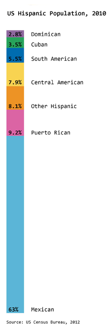
The Hispanic population is the fastest growing minority ethnic group in America. In the previous post about Race and Ethnicity in America, I showed the overall racial and ethnic proportions in America (2010 data). The graphic here specifically looks at what we mean when we say Hispanic in America. The predominant country of origin for Hispanic Americans is Mexico, accounting for almost two-thirds of the Hispanic population (63%). The Mexican American population continues to grow; Mexico is a much more populous place than, say, Puerto Rico, Cuba, or the Dominican Republic which is one explanation for the disparity in locations of origin. However, because Puerto Rico is part of the United States, it is the next largest source of Hispanic Americans at 9.2% followed closely by Hispanics from Central American countries at 7.9%.

What needs work

Admittedly, the graphic is nothing special just a stacked bar. I’m sharing it because it seemed miserly of me withhold it since it offers a better understanding of the ethnic make-up of America than the previous graphic alone. I probably should have posted it in the previous post, but it’s too late for that now.

References

Ennis, Sharon, Merarys Rios-Varga, and Nora Albert. 2011. The Hispanic Population. Census Briefs 2010. US Census Bureau.

Increase and decrease in Hispanic population in the Dakotas, Minnesota, Iowa, Nebraska, Kansas, and Oklahoma | 2010 Census

What works

This is a quiet story, the kind of thing that may or may not be picked up by a major national newspaper like the New York Times. Rural America is often used as a political flag to wave by politicians, but there is not often too much coverage of day-to-day life. The 2010 Census clearly shows,

The Hispanic population in the seven Great Plains states shown below has increased 75 percent, while the overall population has increased just 7 percent.

What is equally odd is that this story is running two graphics – the set of maps above and the one below – that more or less depict the same thing. I salivate over things like this because it gives me a chance to compare two different graphical interpretations of the same dataset.

The two maps above includes a depiction of the change in the white population as a piece of contextual information to help explain where populations are growing or shrinking overall. These two maps show that 1) in many cases, cities/towns that have experienced a growth in their hispanic populations also received increases in their white populations (hence, there was overall population growth) but that 2) there are some smaller areas that are experiencing growth in the Hispanic populations and declines in the white populations.

The second map shows only the growth in the Hispanic population without providing context about which cities are also experiencing growth in the white population. Looking at the purple map below, it’s hard to tell where cities are growing overall and where they are only seeing increases in the Hispanic population which is a fairly important piece of information.

Percent change in hispanic population in the Dakotas, Minnesota, Iowa, Nebraska, Kansas, Oklahoma

What needs work

For the side-by-side maps, the empty and colored circles work well in the rural areas but get confusing in the metropolitan areas. For instance, look at Minneapolis/St. Paul. Are the two central city counties – Hennepin and Ramsey – losing white populations to the suburbs? That is kind of what it looks like but the graphic is not clear enough to show that level of detail. But at least the two orange maps allow me to ask this question. The purple map is too general to even open up that line of critical analysis.

This next point is not a critique of the graphics, but a direction for new research. The graphics suggest, and the accompanying article affirms, that Hispanic newcomers are more likely to move into rural areas than are white people. Why is that? Is it easier to create a sense of community in a smaller area, something that newcomers to the area appreciate? If that is part of the reason new people might choose smaller communities over larger ones, for how many years can we expect the newcomers to stay in rural America? Will they start to move into metro areas over time for the same reason that their white colleagues do?

Are there any other minority groups moving into (or staying in) rural America? Here I am thinking about American black populations in southern states like Alabama, Mississippi, and Arkansas. Are those groups more likely to stay in rural places than their white neighbors? For that matter, what about white populations living in rural Appalachia. Are they staying put or are they moving into cities like Memphis, Nashville, and Lexington?

How do things like educational attainment and income levels work their way into the geographies of urban migration?

References

Queens College Department of Sociology. (13 November 2011) Changing Face of the Rural Plains [information map graphics] Queens College: New York.

Sulzberger, A.G. (13 November 2011) Hispanics Reviving Faded Towns on the Plains New York Times: New York.

Percentage of US citizens holding passports, by state
Percentage of US citizens holding passports, by state | Andrew Sullivan

Passport background

In 2008 as part of the war against terror, US citizens were required to have a passport to travel to countries like Canada and Mexico that had previously allowed passport-free travel. US citizens could drive or walk into Canada and Mexico with a driver’s license and be allowed to drive or walk right back in. In 2011, we see from this map that even now, not all US citizens have passports, not even close. Getting a passport is time consuming, costly, and generally requires some evidence that the person applying for the passport intends to travel outside the US. That last requirement is kind of a no-brainer, why would anyone want to go through the effort to obtain a passport if they never planned to leave the US?

What works

Always skeptical about mapping data that could appear in a table or chart, I have decided that I’m neutral on this particular use of mapping as a presentation device. If the map had included Canada and Mexico rather than just making the US appear to float in space, I would probably have been more convinced that the map was the way to proceed with this information. If I had created a chart or a table, I would have divided the US states into two groups: those that border foreign countries and those that do not. Have a glance at the map again and you will see that the states bordering foreign countries have higher percentages of passport holders, on average, than those states that do not border foreign countries. Florida and Illinois do not border foreign countries and yet they both have high percentages of passport holders. In the Florida case, I would say it’s almost as if Florida borders foreign countries since so many of its near neighbors are island nations – Haiti, the British Virgin Islands, the Dominican Republic, and so forth.

Illinois is home to Chicago, a destination for immigrants and immigrants often leave family in other countries whom they would like to visit. Thus, they will need passports. The same is true for most big cities – New York and California (home to New York City and Los Angeles) also have large immigrant populations and large numbers of passport holders. On the other hand, Saskia Sassen might point out that what’s going on in Chicago, LA, and New York is that all of these cities are global cities, hubs of activity in Finance, Insurance and Real Estate (FIRE industries). These FIRE industries are global industries and require their workers to travel internationally at higher rates than the same kinds of workers in other industries.

It would be interesting to compare the rates of passport holders to both the rates of first generation immigrants and the proportion of workers in the FIRE industries in all these states.

What needs work

As I mentioned, presenting this information as a map begs to have Canada and Mexico included. In order to visualize the story here, it would be helpful to see what is happening at the borders, to remind ourselves that the US does not simply float in space. It is geographically specific and it matters that some states have international borders and others do not. Sometimes these borders ARE the story and I think when we’re talking about passport holders, the borders are important.

If this information were to be presented as a set of bar graphs, we would risk some information overload since there would be 50 bars. But that might be alright if it became instantly visually clear that the border states have higher rates of passport holdership than the interior and non-bordering states. Plus, with a bar graph, the numbers could have been layered on each bar (and really, they could have been layered on each state in the map) so that we would be able to get a more precise calculation. Simply knowing that we are working with some number in a 10% range is kind of sloppy for my tastes. That’s just me. And sometimes with information like this it’s silly to try to get granular because the data collection method could have a fairly wide margin of error. Though I should hope that the feds know who is holding passports. I suppose people could apply for them in one state and then move to another state. The feds may not know about moves following passport application and that could introduce some fuzziness.

Note: I tried to go to the original source of the map several times but the page timed out repeatedly. Therefore, I ended up citing Andrew Sullivan at the Atlantic since that is where I encountered the map and it is a website that I believe you can visit whereas cgpgrey.com/blog is not visit-able. If I had been able to visit I might have been able to figure out where the passport data came from in the first place – presumably some federal department.

References

Sullivan, Andrew. (8 March 2011) Map of the Day: How many Americans have a passport, by state in The Daily Dish at The Atlantic online. [Graphic by cgpgrey.com/blog]

Sassen, Saskia. (2001 [1991]) The Global City: New York, London, Tokyo, 2nd ed. Princeton, New Jersey: Princeton University Press.

Immigration to the US | Absolute Numbers
Immigration to the US | Absolute Numbers, courtesy of Thomas Brown and IBM's Many Eyes Tool


Immigration to the US 1900 - 2000 | Relative flows from sending countries
Immigration to the US 1900 - 2000 | Relative flows from sending countries, courtesy of Thomas Brown and IBM's Many Eyes Tool

What Works

Before you read any further, ask yourself which one of these graphs is most useful. Which one has the most information? If you had to get rid of one of them but still be able to explain the basic flows of people into the US over the last century, which one would you keep? And would your story be much weaker, somewhat weaker, pretty much the same after the loss of one of the graphs?

First, I was moaning the other day about a graphic – like the one I posted recently about prescriptions for treating mental illness in the US – in which color is used to make it look like there is important information being encoded when, in fact, the colors are just pretty, nothing more. I am happy to report that in this case, the colors are not only useful, but necessary. Try to imagine looking at this thing in gray scale. It would be nearly impossible to read. So kudos for color in general. In specific, I probably would have tried to group the countries that are near each other in the world within a color family. Sweden and Norway are good examples of what I would have done throughout – they are both green, just different shades. That makes good logical sense. On the other hand, Ireland and the UK are not in the same color family and it confuses me. I also don’t see great geographic or other similarities between Canada/Mexico and China. So I would have kept the Canada and Mexico as they are and found a different color for China.

Now I’m going to get back to the question I asked at the beginning of the post: could you do without one of these graphics if you had to axe one? It’s a leading question and the answer is clearly: yes. The first one is far better than the second one. Looking at absolute flows by country of origin gives a much more interesting and fully articulated picture than looking at the relative values of people coming at any one point in time.

What Needs Work

The numbers behind this graph were pulled from Census Data, a good place to go because they are the most reliable numbers we are likely to find (at least with respect to legal immigration – undocumented immigration is, well, undocumented so the Census doesn’t help). However, the thing about Census Data is that it’s going to show us flows for a decade at a time and I wonder if it might be a little misleading to show these numbers as an augmented line graph. A bar graph might be better and here’s why: smoothing the lines implies decade reliant time trends that don’t exist. Unfortunately, in the real world, important decisions do not always take place in the same year the census is taken. The Immigration Reform Act of 1965 was right between decades. Now I know you’re thinking something along the lines, ‘anyone who studies immigration is going to know when that reform act was and when WWI, WWII, the Depression, and all sorts of other important historical events took place. we’re not idiots.’. I agree; you are not idiots.

On the other hand, if I were to create this as a bar graph, I would have the freedom to actually locate the legislation as a graphic element – a line flying a flag announcing the name of the act, for instance – right between the bars for 1960 and 1970. But of course, that would make it difficult to see how the flows are changing over time, so I might superimpose a kind of shadow version of the current line graph over (or under) the bars so that the eye can be aided in its path from one bar to the next. Line graphs do show change much better. But I like the idea of being explicit with the time periods in which the measurements occur and with the notion of leaving graphical space to add important contextual details.

This graphic was created by Thomas Brown using IBM’s free Many Eyes visualization tool. I wholeheartedly support IBM and the other companies and organizations that are making powerful visualization tools available for free. In case you aren’t familiar with them, they allow users to input data and then they take that data and produce visual representations of it. In this case, the full version of the graph is interactive – hovering the mouse will reveal greater detail about any given flow at a point in time. This is a great thing. I support layering of information. The layering available at Many Eyes does not quite make up for the inability to layer in the way that I described above, but I’m not disappointed with IBM. There are already tools for manipulating graphics. The best way to use IBM’s tool is not to expect it to do everything, but to take their visualizations and then further enhance them in photoshop or your favorite image editing software.

Also Note

This graphic is about spaces but it is not a map. For whatever reason, people use maps whenever there is mention of geography, and even sometimes when there isn’t, even though the map is often not adding to the story and making it harder to immediately grok what the important patterns are. Just because geography or mobility might be part of the story you are trying to tell, it isn’t necessary to use a map to encode your narrative visually.

References

Thomas F. Brown. Immigrant Origins via email on 11 October 2010.

IBM’s Many Eyes data visualization tool.

US Census Historical Statistics for Immigration by Number and Rate and Immigration by Leading Country or Region of Last Residence.

Migration into and out of Los Angeles, CA (2008)

What works

This is an interactive graphic situation so to get the most out of it, I recommend clicking through to forbes.com and playing around.

What works is that we can see a lot of internal migration between Los Angeles and other west coast cities as well as between LA, Florida, and the DC-NYC-Boston corridor. I know plenty of bi-coastal folks so the picture matches up with my experience. To get the proper context, I suggest you click through and pick some rural counties to see how much people tend to move from small place to small place and from big place to big place but not so much from very small to very big or vice versa.

Overall, what the interactive graphic ends up showing us is that people move quite a bit. The map gets saturated with lines.

Man, we can really make some cool graphics – and interactive ones at that – with the ridiculous capacity of desktop computers these days. This is a data-driven graphic that would have been nearly impossible not that long ago.

What needs work

There is no comparison for this graphic. I can’t tell if all this migration is more than normal, trending up, trending down, or anything of that nature. Sheer volume at one time can generate lots of questions but it doesn’t answer many.

I’d also be curious to know if the movers are evenly spread across the life course. Plenty of people move to go to college and then again when they leave college, or so I think. And there has been plenty of ink spilled about retirees moving south from places like Chicago and Minneapolis. Then, about ten years ago, I remember reading stories about the plight of the managerial class having to move around within their multi-national corporations to keep progressing in their companies all through their mid-life. With all those half-baked hypotheses, I would love to see how life stage impacts internal migration.

References

Bruner, Joseph. (15 June 2010) Map: Where Americans Are Moving at forbes.com.

Annual change in U.S. GDP under different scenarios | 2009-2019

What Works

We are able to see the results of three hypothetical assumptions regarding the treatment of unauthorized immigrants and the impact that could have on the GDP of the US from 2009-2019. While I often advocate trend lines for showing changes over time, in this case, what we are interested in is not just a trend over time, but the difference between the three outcomes in each year. For that reason, the choice of bars works better than would the choice of trend lines. Seeing all the three options on the same graph neatly summarizes the overall findings of the report. If you are interested in learning more about just how these projections were made, all of that is detailed in the report [link below in references]. One important note that the report mentioned more than once is that the cost of the mass deportation scenario does not include the cost of deporting individuals (which would be legal and physical), it just represents the impact on the economy of removing unauthorized workers.

What Needs Work

I snipped this graphic out of a report, so the following critique is for me more than for the graphic creator. Because this kind of projection requires so many assumptions and simplifications, providing summaries of the most critical assumptions is necessary for the proper cognitive digestion of the infographic. The report contains sufficient discussion and references, but in a world where people like me clip graphics and stick them in other reports or on blogs, savvy designers will include longer captions [the original caption is included in the image file] or other explanatory text even if that same information is included in the formal text. Hyper text culture is spreading. It is far more common now to put together a little bit of this from here and a little bit of that from over there in search of just that bit of information that we think we want rather than reading/watching the full, originally constituted work. Love it or hate it, this hyperlink no place is the place where we have arrived.

References

Hinojosa-Ojeda, Raúl. (7 January 2010) “Raising the Floor for American Workers: The Economic Benefits of Comprehensive Immigration Reform”. Center for American Progress.

"Who is coming to America?" GOOD magazine Transparency by Thomas Porostocky
Who is coming to America? GOOD magazine Transparency by Thomas Porostocky

What works

This is another graphic excerpt from GOOD magazine’s Transparency infographic collection. Note that I cropped out country-by-country break downs detailing how many people arrive as refugees and how many arrive as relatives of US citizens. Most immigrants to the US come as relatives of US citizens. That’s just how immigration law is set up, much to the disappointment of Bill Gates and other tech sector employers who used to frequently haul themselves to Washington to lobby for adding more visas for talented workers.

This graphic is clever, far more clever than many similar depictions of the same kind of data. I’ve seen pie charts where each piece of the pie represents a country. Bar graphs. Maps with a bunch of numbers and arrows. The concept here is both clean/easy to grasp at first glance and well executed. It would have taken me a minute to think of moving from a 2D flag to a 3D flag so that words and numbers could wrap the edges of the bars but I do think that helps present a cleaner image. Fewer characters on each bar.

Symbolically, it reminds us that America is constituted almost wholly by immigrants – this being the current numerical distribution of the countries of origin.

Though you cannot see it from the way I’ve cropped it, the text explains that these are LEGAL immigrants to the US. So, yes, Mexico sends the most legal immigrants to the US. That’s key. Americans tend to assume all immigrants from Mexico are illegal and that’s far from true.

Also, kudos for skipping flag textures on the bars. I’ve seen far too many similar graphics riddled with flags and that seems like a good idea but doesn’t work well because Americans just don’t know what the flags of other countries look like. Flags do not equal national icons, at least not in the eyes of Americans. Plus, if these bars had been wrapped in national flags it would have been symbolically interesting – America is made of all these different countries – but visually gross.

What needs work

I can’t tell from this graphic what the deal is with the “unknown” country category. I would have appreciated a little asterisk to clear that up (I know I cropped out a majority of the graphic so you can either take my word that there was no asterisk or you can click through to the full graphic above and check it out for yourself).

To emphasize the importance of Mexico as a sending country, I probably would have put it up in the shorter stripe area. Ditto for China. It looks like Mexico would have taken up two full short stripes and China would have taken a full shorty plus a little more.

I also would have found a way to group regions together. So El Salvador and Guatemala could have been close to Mexico and the Koreas and Russia could have been close to China.

References

Porostocky, Thomas. (2009, May 5) “Who is coming to America?” GOOD Magazine Transparency Infographic.

Migration Information Source clearinghouse for all sorts of information about US migration patterns, policies, and studies.

immigrants_suburbs_sm

What Works

This is beautiful. Just look at it and tell yourself why it works. Think about how crappy it would have been if all the cities had been crammed on to one graph. Stringing them out like this, one city per graph, tells the story of immigrants moving to the suburbs so elegantly. The density increases from left to right with time series adequately represented for each city.

Relevant Resources

DeParle, Jason. (2009 April 28) Struggling to Rise in Suburbs Where Failing Means Fitting In New York Times, part of the Remade in America series.

Diagram of Binghamton School Shooting

What Works

Not sure. The maps are helpful enough.

What Needs Work

First, the numbers 1-5 need to clearly relate to something. I was looking for them to relate to particular areas but then I realized they were more like time stamps. If that is the case, then it would be nice to have the actual time stamps or some kind of approximation. More importantly, I had to ask myself if this graphic helped me understand the “sequence of events” at all. And it didn’t. But maybe others see some value here?

Relevant Resources

The Sequence of Events in the Binghamton Shooting

Internal Migration - Pew Research Center

Ranking the States by Net Movers

Note to Readers

I want to thank Mike Bader, PhD candidate in Sociology at the University of Michigan, for pointing me to these graphics. Please follow his example and send me what you come across.

In another note, for this post you really have to click through and play around with the interactive graphics at Pew or you are going to miss out on the best part.

What Works

These graphics are high quality and thoughtful, they offer more the more you look at them and play around with them. I especially like the “net movers” diagram because it works as a static graphic and as an interactive graphic. They are high quality and represent a clear effort on the part of the people at Pew to develop information graphics as a tool of information dissemination. The immigration data they use is all available from the Census Bureau (either from the decennial census or from the American Community Survey) and here that data has been masterfully presented.

The interactive graphic based on the map works the best. Because it offers just a bare minimum of information at first glance – either positive or negative net migration – users are compelled to actively engage. They have to actually move the mouse over the graphic in order to unlock the richness. It’s not a huge hurdle, there aren’t too many people who will be deterred from the interaction because it’s just too much for them, but it does mean that they have to have some kind of motivating question. And asking a question, even it the question is so simple its almost sub-conscious, “what does this thing do?” means that the user is actively looking for an answer. Pedagogically, when learners generate their own questions, they are more likely to retain the information presented. For this reason, most interactive graphics are likely to be better learning tools than would, say, a list of bulleted points about immigration patterns.

I also like the detail available in the pop-out tables. Tables are tricky beasts – they have the ability to offer a great deal of precise data which is generally tantalizing to empirical researchers. It’s tempting to build row on row and column on column of exacting detail in a grid that allows for efficient reference. But tables are much better for answering questions for posing them. If you know what you want to look up, you’re happy to have a table. But if you don’t come to a table full of data with a question, it’s highly unlikely that seeing table data is going to help you generate a question. Think: how often do you pour over the train schedules for distant cities? Probably only when you’re about to travel to those cities. A table as a graphic is about as interesting to readers as a bus schedule for nowheresville. On the other hand, if you happen to live in nowheresville, you are extremely motivated to check the train schedule because it’s imperative that you get on a bus to somewheresville.

This graphic wouldn’t have worked if it were simply a table by state with all the same data that is in the mouseovers. And yet, that same data presented in bite size table format in a rollover is suddenly interesting because the user was internally motivated to find out. Even if the motivation was no more than, “hey, what happens on mouseover?” that is enough to hook viewers into the project going on here. It’s kind of like a modern version of jack-in-the-box. An empty box is so boring one might not even see it. But a box that something is going to pop out of is irresistible. It’s not like the act of mousing over or winding a spring is inherently interesting. Both are boring in themselves. But even a little element of surprise can not only motivate people to act, but can spark a spot of enthusiasm.

What Needs Work

The static graphic with the giant arrows floating around the country wastes its 3D quality Does anyone else see something like a giant game of chutes and ladders where emigrants climb up out of one area and then turn into immigrants as they slide down into a new area? Maybe it would be more engaging if little animated people were actually sliding around the country. The interactive graphic offers so much more information than what is contained in the static graphic – let’s face it, all we’ve got is a loose sense that there is internal movement – that I can’t even stand to look at this for more than about ten seconds before I move on to the interactive part. However, static graphics CAN be just as rich, offering just as much deep information, as interactive graphics. This one fails, but there have been many successful static graphics featured. (list of static graphics here – Jaegerman, death penalty, tomorrow’s post)

Relevant Resources

Cohn and Morin. (2008, December) Who Moves? Who Stays Put? Where’s Home?. Pew Research Center.

Keegan, M. and Rountree, S. (2008) Comings and Goings: Migration Flows in the US Pew Center for Social and Demographic Trends.