Archive: Mar 2009

Stimulus Package - Washington Post (Laura Stanton)

What Works

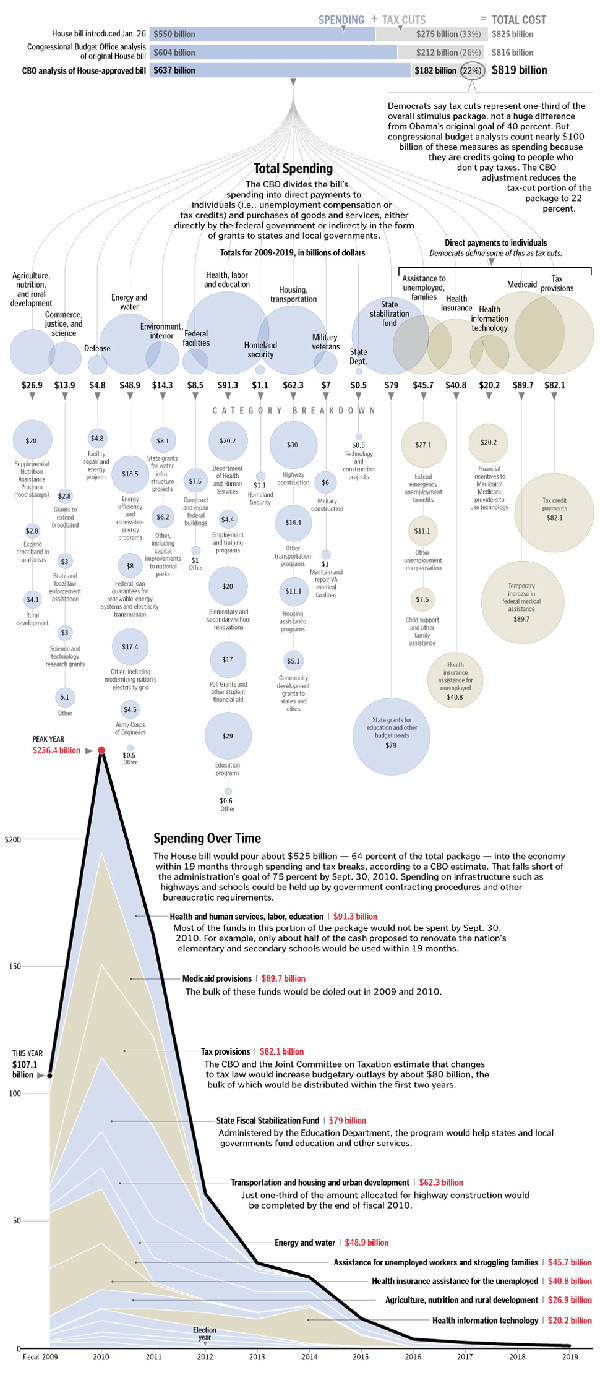
First, the paper allowed three different graphics to run – the overview provided by the bars at the top that show how the stimulus is divided by spending and tax cuts, the more granular breakdown of the pigeonholes for these dollars, and the time line that helps us understand when the money is going to hit the economy (and when we can expect all these transit programs to get going). Second, the main graphic does two things. It is both a fairly simple, readily understood cascading design that draws each category down to its constituent parts across the vertical access. It is also artful – when I look at this I see a sort of mobile hanging over head offering glassy baubles of funding to the madding crowds (ie the states). I’m not trying to insult the states here. In this economy, we’re all the madding crowds, but I really like the fact that the graphic incorporates mood and sensibility. Third, the timeline is a critical component of the stimulus package because there is so much anxiety about when this down turn will be ending. The stimulus money hitting the market is not a direct indicator that the downturn will end, but it is an indicator of when we can start looking for positive economic signs. Furthermore, the timeline could almost stand alone as both a timeline and a description of how the money was allotted. It is nice to be able to look at the package’s pigeon holes/piles of money in two different ways.

I also smiled when I didn’t see a map. Not every story can be visually summed up by the deployment of a shaded map.

What Needs Work

This blog isn’t wide enough to satisfactorily display the graphic so click through to get the whole story.

Relevant Resources

Congressional Budget Office

Stanton, L. (2009, 1 Feb.) Adding up the $819 Stimulus Package – Graphic. The Washington Post.

Yourish, K. (2009, 1 Feb.) Adding up the $819 stimulus package – Reporting The Washington Post

Cabspotting - San Francisco

What Works

First, the elegant sophistication of this graphic is breathtaking. I love watching it and I have watched it for long enough to start asking questions about it. Maybe I am different than other people, an outlier of some sort, but in this case I don’t think so and that’s why my own fascination indicates a larger virtue of the graphic. If it draws people in and gets them asking questions, it is doing something right. Holding eyeballs in this media saturated world is a triumph in itself. Having answers to the questions that are posed is a secondary but even more critical step. To figure out what you’re looking at, here’s what the folks who made it have to say for themselves: “Cabspotting traces San Francisco’s taxi cabs as they travel throughout the Bay Area. The patterns traced by each cab create a living and always-changing map of city life. This map hints at economic, social, and cultural trends that are otherwise invisible. The Exploratorium has invited artists and researchers to use this information to reveal these “Invisible Dynamics.” The core of this project is the Cab Tracker. The Tracker averages the last four hours of cab routes into a ghostly image, and then draws the routes of ten in-progress cab rides over it.”

Second, they are right that just knowing where cabs go is more than knowing where cabs go. It’s knowing about urban space over time. It’s certainly knowing where the airport is (and that airports are far away). Looking at this we get to see the grid of the city and the longer stretch of highways and bridges bringing people in/out. It would be nice to see what this sort of ghostly cab mapping technique would reveal about cities I know a little better than San Francisco. Keep this site tucked in your back pocket for later this year, all you ASA meeting-goers.

What Needs Work

I just wish there were a simple way to say a little more about the cabbies themselves, who end up looking like infrastructure or phantoms, rather than actual people. In New York, 91% of the cab drivers are immigrants and only 1% are women (2006 Schaller Consulting). Is there a way that this cab-tracker could become a little more about the humans in the city?

Relevant Resources

Richards, P. and Schwartzenberg S. Snibbe S. and Balkin A. cabspotting San Francisco.

Schaller Consulting. Repository of Reports on Cabs in New York and beyond

Plaut, M. (2007) Hack: How I Stopped Worrying About What to do with my life and started driving a yellow cab. New York: Random House.

Buddhacab blog written by a New York yellow cab driver

amazon.com, walmart.com, target.com, kmart.com
City Data
City Data

What Works

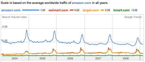
This is a graphic generated by one of google’s trend analysis tools. I simply typed in the web addresses I was curious about and google graphed their relative traffic patterns, using the first page I entered to set the scale. In their words, this is what the tool does: “Google Trends analyzes a portion of Google web searches to compute how many searches have been done for the terms you enter, relative to the total number of searches done on Google over time. “ If I were you, I would ignore the value of the scale and just keep in mind that it is relative. We’re measuring not total volume, but the volume of these four sites relative to one another.

Amazon clearly has far more traffic than the other three sites. Because walmart, target, and kmart rely on their physical stores, just looking at this web traffic does not tell you much about relative sales. I don’t who else is like me, but I often use amazon as a sort of loosely organized reference site, finding it faster to look their for publication dates of books than to go to my library’s site or fish the book off my shelf. I might be an outlier in this regard – most people don’t spend time every day wondering about publication dates – but there is probably a fair amount of traffic on amazon related to their product reviews that may not result in sales at amazon. All of this activity generates traffic, not sales. All three of the other retailers also feature customer reviews, by the way.

What works here is sort of unclear. On the one hand, just look at how similar walmart.com and target.com are. They track each other so closely they are visually difficult to distinguish. And just look at how important the holidays are to all these retailers.

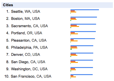
The city data relies heavily on which website is input into the search field first. Seattle might not have even been included if I had put walmart.com first, but many cities in the south would have been. Minneapolis would be up there if I had put target.com first. kmart.com first motivates Philly to the front of the pack.

What Needs Work

My biggest critique of this sort of thing is that it’s unclear what the heck to take from it. If you are just trying to beat some competitor, having google show you their relative traffic is immensely useful. But what else is this good for? Anyone?

Let me just point out that this only works for large sites. Google can’t tell us much about the vast sea of smaller sites.

Open Access – Transparency

In the end, though, the move towards making data publicly available is fabulous. I can’t see how this particular instance is broadly useful to me – it’s fascinating, sure, could be good for marketing departments internal to these companies, but then what? My confusion just means that I am a short-sighted fool. Google should be applauded for creating a non-prescriptive tool to explore the data they have that is so basic it can be used by anyone for who knows what.

Relevant Resources

Benkler, Y. (2006) The Wealth of Networks: How Social production Transforms Markets and Freedom. New Haven: Yale University Press.

Google Trends Information.

Google Trends the digital widget or digi-wigi.

Himanen, P. (2001) The Hacker Ethic. New York: Random House.

Raymond, E. (2001) The Cathedral & the Bazaar: Musings on Linux and Open Source by an Accidental Revolutionary. Sebastopol, CA: O’Reilly Media.

US population growth 1790-1990 [freeze frame at 1920] - University of Kentucky Appalachian Center
US population growth 1790-1990 {freeze frame at 1920} - University of Kentucky Appalachian Center

Link rot note

This post used to source a population growth animation from zachofalltrades.net but that website is no more. The University of Kentucky Appalachian Center is better, so count yourselves lucky if you missed the original post in favor of this update.

What Works

First, you must click through and watch the animation. Praise #1: yay for gifs.

Like the previous post that looked at China, this animation is trying to tell a story about population growth over time. The major difference is that the Chinese example was strictly demographic – looking at variables like gender and age but not at all concerned with geography. This one shows both geography and population growth though it does not include information about gender, age, race, etc.

What Needs Work

If this graphic were three dimensional, if density piled up, it would start to ‘feel’ heavier over time so that the same way that the westward expansion of the population just appears without you having to puzzle it out, the density of population in cities would be simply obvious. This is not meant to be a dig to the graphic’s creator. I just offer this critique as a way to think about just why and how ‘seeing is believing’. Watching the population move west is certainly a ‘seeing is believing’ moment because viewers do not have to think, they just have to watch. Realizing that the population of the US is now hugely larger than it was back in the 1880’s actually takes a little thought. You have to realize that not only did people move west, but they continued to live in the east in greater densities which is indicated by the size of the yellow circles, but would be even more obvious if the cities were like little hillocks on the landscape. Big yellow dots equaling density requires a move from the ‘seeing is believing’ to something else. If, however, the map grew in the third dimension as a more direct representation of the mass of humanity sitting on the face of the earth at these locations, we’d be back in ‘seeing is believing’ territory.

A graphic that is a ‘seeing is believing’ creation is instantly legible and can free your brain to think about other things which is a good thing. On the other hand, a graphic that achieves a ‘seeing is believing’ mechanism will end up obscuring complexity. This is good when that complexity does not add to the ability to think through the next set of concerns, but can be a serious drawback. It is good to be able to get a diversity of people able to quickly grasp an argument, but there is a danger in presenting an hermetically sealed glossy image.

Relevant Resources

University of Kentucky Appalachian Center. US Population Growth from 1790-1990

Population Growth Animation - China

First Thing’s First: Apologies

My apologies for failing to post for a few days. If you noticed, I’m flattered. I had some deadlines and limited access to the internet late last week. Unfortunately, March is a very busy month and I will likely have this problem again before the month is out. I’ll try to make up for it when I can.

What Works

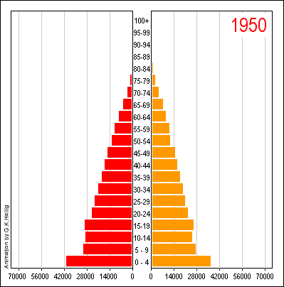
I have always been a fan of the population by gender and age chart, even in the static form that you see before clicking through above. It is quite an achievement to clearly represent three different variables on a two dimensional graph. It helps immensely that gender here is a binary value. If it were tertiary or tertiary plus, this strategy would fall apart. Once you click through, you’ll see that the animation adds yet another variable, time. And time is a real kicker here. You can see how China’s population goes from having many young people and few old people to 2050 where the largest category is between 60 and 64 years old. Great way to take an old graphic technique – the static version – and animating it.
(I would love seeing this thing as population by age sticking married people on one side and unmarried people on the other as an animation.)

What Needs Work

The colors and overall treatment of the graphic as a designerly element. Red and orange makes it look a little like it’s yelling ‘Caution! Proceed at your own risk!” the whole time. But then, I guess we all have to worry about what is going to happen when the population pyramid becomes a slender pillar with an ionic capital.

Relevant Resources

United Nations (1999): World Population Prospects. The 1998 Revision. New York. Link to animation. [graphic credit to Heilig, G. 1999]