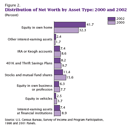
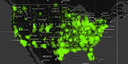
economics

The following graphs all show how much of American’s wealth is (or, um, was) in the form of home equity. They are all based on 2002 data, several years before housing prices hit their peaks, which means by the time the housing bubble burst, home equity was an even larger proportion of all net worth.

It’s not that I didn’t already know the economy was in trouble. That’s obvious–I live in Vegas, all I have to do is drive around a little and see all the houses sitting empty. But looking at these images I kept thinking, “a good portion of that home equity wealth is just gone.” On paper, we had all this wealth, and people borrowed based on it…and a lot of it is simply gone. Just…poof. Gone!

This one shows what percent of all net worth in the U.S. falls into various categories.

Here we have median net worth in 2002 for different age groups…and then the lighter purple bar, which is median net worth if you took out home equity:

A similar breakdown, except by race, not age this time. Notice how much Blacks and Hispanics lag behind Asians, and how much they lag behind non-Hispanic Whites in terms of net worth:

On the up side, if the stock market keeps going down, then home equity as a percent of our net worth will go up again because we’ll have lost so much in stocks. So, you know, look on the bright side!

All of these graphs came from “Net Worth and the Assets of Households: 2002,” written by Alfred O. Gottschalck and published by the U.S. Census Bureau in April 2008.

According to the U.S Bureau of Labor Statistics, weekly earnings rose 0.9 percent last year and the overall inflation rate was 4.1:


Found at Everyday Sociology.  Click to enlarge.

Angela B. brought our attention to an animated map showing, over the space of some seconds, the growth of Walmart across the United States from 1962 to 2007.  Below is the final image.  It’s worth a click to watch the growth yourself.

Jay Livingston over at Montclair Socioblog reports on a report by the Pew Center. First this image:

Jay writes:

When Reagan asked this question in the 1980 presidential debates, most people, according to Gallup felt that yes, they were better off – 52% vs. 25% who felt they were worse off. That’s puzzling, considering the apparent success of Reagan’s question – he won the election handily.

The interesting result from the Gallup numbers is that when Reagan left office – after the “Reagan recovery” cherished by anti-tax, anti-regulation conservatives – the numbers were identical. If you look at actual changes in median family income, you see a slight decline in the Carter years and an increase in the Reagan years. But these changes aren’t reflected in how people felt, at least not as measured by Gallup.

This year’s numbers show optimism at its lowest ebb since Gallup started asking the question in 1964. “Better off” still tops “worse off,” but by only 41% to 31%. Even more surprising to me was the proportion of these self-identified middle-class Americans who rate their quality of life as low (five or less on a ten-point scale).


Marc sent in this image (found here):

According to this site, the photo was taken by Margaret Bourke-White; this site, where you can buy old issues of LIFE magazine, lists the photo in the index for the February 15, 1937, issue. Apparently the people standing in line were flood victims.

This is a great image for sparking discussion about “the American Way” and what that was meant to be (clearly white and presumably middle-class, from the mural), and the ways in which non-whites (and poor whites) are often invisible in depictions of what America is. And, of course, it could be a great image for a discussion of rhetoric and propaganda (for instance, murals proclaiming how wonderful the standard of living is even though the Great Depression was by no means over).

Thanks, Marc!

This interactive chart in the NYT uses shapes to represent how much the average American spends in different categories. Larger shapes make up a larger part of spending; colors show changes in prices from March 2007 to March 2008. Red means an increase in the relative cost, light tan and white relative stability, and blue a decrease.

Note from Gwen: Since it was causing some people with Firefox problems, I’m changing it so you have to click to see it, rather than having it come up automatically when you visit the site. Hope this helps.

more...

Worldmapper offers maps in which the actual land area is morphed to represent various disproportionalities across the globe. The website has over 300 maps! Thanks 73man for the tip!

I borrowed a few examples and pasted them in below. The first map is an actual land area map for reference.

Territory size shows the proportion of worldwide net exports of toys (in US$) that come from there. Net exports are exports minus imports. When imports are larger than exports the territory is not shown.

Territory size shows the proportion of worldwide net imports of toys (in US$) that are received there. Net imports are imports minus exports. When exports are larger than imports the territory is not shown.

Territory size shows the proportion of carbon dioxide emissions in 1980 that were directly from there.

Territory size shows the proportion of all territory level decreases in carbon dioxide emissions between 1980 and 2000, that occurred there.

Territory size shows the proportion of state military spending worldwide that was spent by that territory in 2002.

Territory size shows the proportion of species worldwide that became extinct between 1500 current era and 2004, that became extinct there.

Territory size shows the proportion of all people over 15 in the world living with diabetes who live there.

Territory size shows the proportion of all people aged 15-49 with HIV (Human Immunodeficiency Virus) worldwide, living there.

See more alternative maps here.

.

This figure demonstrates the shift from an economy dominated by manufacturing, to one dominated by information and services. As I understand it, it is this shift that is driving the shrinking of the middle class.


Image borrowed from http://www.whosyourcity.com/.