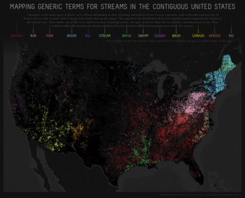
Dolores R. sent a link to a map created by Derek Watkins to show how the names given to geographic features reflect cultural patterns. Using a database of names officially accepted by the U.S. Board of Geographic Names, Watkins mapped generic terms used in the names of streams (excluding “creek” and “river,” which are commonly used throughout the U.S and were plotted in a gray that fades into the background):
The generic terms reflect historical immigration patterns. “Kill” appears in areas of New York originally settled by the Dutch; “cañada,” “arroyo,” and “río” indicate areas of Spanish exploration and settlement in the Southwest; of course, Louisiana and the surrounding area still reflects its French heritage through the term “bayou.”
The map reflects internal migration and cultural diffusion within the U.S., as well. For instance, Watkins suggests that the patch of red in southwest Wisconsin, indicating the use of “branch,” may be due to the lead mining boom in the early 1800s. Lead mining attracted Appalachian miners to the area, and they may have influenced local naming practices, bringing along terms common in Appalachia.
For more on the interconnections between geographic names or terms and larger cultural patterns, Watkins suggests reading Names on the Land: A Historical Account of Place-Naming in the United States, by George Stewart (2008). Another excellent source is Wisdom Sits in Places: Landscape and Language among the Western Apache, by Keith Basso (1996).


