
The website If It Was My Home (and yes, they know about the grammar error) allows you to get a better grasp on the size of the area affected by the BP oil leak. They use National Oceanic and Atmospheric Administration’s daily updates on where the oil will reach in the next 24 hours and allow you to use Google Maps to position it anywhere you want. It’s easier for me, at least, to get an idea of the dimensions of the area we’re talking about when I can imagine it on an area I’m familiar with than seeing it on a map of the ocean.
Here’s the oil leak area centered over Las Vegas, where I live:
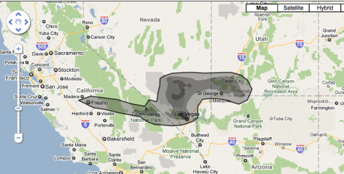
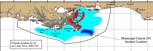
The darker the shade of gray, the denser the oil. Here is the current NOAA surface oil projection for the next 24 hours; red indicates places oil may hit shores:
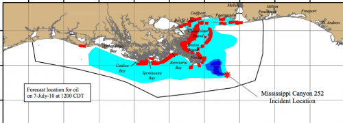
Today’s 72-hour projection, which shows the range extending qute a bit to the west, and more affected shoreline:
Thanks to Kate W. for the link!
Related posts: using the oil spill to advertise cheap flights, should we clean up oil-soaked wildlife?, the Gulf oil industry, BP buys Google search terms, BP gives Florida money for advertising tourism, protesting BP, and the power of images of environmental disasters.
Comments 6
katyhalo — July 5, 2010
Putting it over the UK, the spill stretches almost the entire distance between Ireland and the Netherlands. Wow.
Amadi — July 6, 2010
Centering the leak on my home in Pittsburgh, PA spouts oil up into Lake Erie and as far west as Fort Wayne, IN. Terrifying.
This comes hard on the news that tar is being discovered on the beaches in Texas now.
Simone Lovelace — July 7, 2010
I just got back from vacationing in Israel, so I tried putting the spill in Tel Aviv. The spill is substantially bigger than the entire state of Israel. The spill stretched East-West, not North South, so most of it ended up in the ocean, but the spill is more than large enough to cover the entire State of Israel.