Crossposted on Rhizomicomm
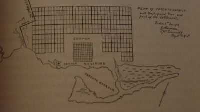
In 1959, my Chicagoan parents visited Toronto, Ontario and the city left little impression upon them. Architecturally nondescript, it was seen as an unfortunate product of postwar growth in an uninspired age. I remembered this and when I was driving from Montréal to Los Angeles in 1992, I didn’t even stop to visit Toronto. My only recollection of the city was seeing a cluster of highrises in the distance while on a huge swath of a highway with express and collector lanes, the mighty 401. Living in Toronto over the past few summers, I’ve found the city to be much more fascinating than I gave it credit and a lot has to do with how much of the downtown core is walkable. I’m reading a book, Walkable City, by Mary Soderstrom that draws heavily on Jane Jacobs, a key urbanist figure here in her adopted Toronto. Toronto from its inception, started with a grid::

Toronto’s grid, unlike that of New York City’s Manhattan, consisted of short streets and encouraged the development of neighborhoods and community. José’s blog earlier this year notes how grids are safer than dendritic street patterns. Jane Jacobs helped to thwart a freeway project, the Spadina Expressway, which would have taken cars from the mighty 401 allowing them access into the heart of the downtown core. The expressway would have encouraged more sprawled developments outside of the core, but some have argued that Toronto’s anti-car policies have driven development out towards the suburbs, with cheaper land and lower taxes. One of the outcomes of the Spadina Expressway failure was the creation of the Spadina subway line, which focused development along that corridor.
Flying into Pearson and seeing maps of the Greater Toronto Area, there is no mistake that there is sprawl. The Toronto I’ve encountered is one of surprises, as the downtown core is walkable and much can be accessed on foot. While I complain about the local mass transit, the TTC, particularly since it’s often crowded and expensive {cashfare of $2.75 CAN is one of the highest in Canada}, it works. If you live in the downtown area, one doesn’t need a car and like in Manhattan, a car is often a liability, rather than a convenience. Nevertheless, I see Toronto as at a city at a crossroads. Increasingly dependent on automobiles in an era of volatile oil prices, with an infrastructure dependent on gas taxes and registration fees. Toronto is the largest city in Canada, comparable in size to Boston, but runs the risk of being gridlocked and subject to the “tyranny of the automobile,” as a prescient 1966 Toronto Planning Commission warned. From a marketing point of view, I see glossy developers’ ads enticing residents with more space and lower prices {and possibly lower taxes} outside of the downtown core, which I’m sure are compelling to many. Unfortunately, many of these developments aren’t factoring in walking. While they may be close to mass transit, they often aren’t in vibrant communities with mixed-use {housing and businesses} and adequate amounts of affordable housing. I’m afraid the thinking is still along the lines of modernity’s arboreal tree, as opposed to the Deleuzean rhizome, but A City Is Not a Tree.
In discussing public financing of infrastructure, a curious split occurs. When discussing freeways, there’s often a mentality of built more to alleviate the strain. Like Internet bandwidth, there can never be too much carrying capacity. The minute one talks about mass-transit, there’s often a discussion of whether or not usage and fare revenues will be sustainable. Transit-oriented development might be a solution, if increases in property values from proximity from mass transit can be leveraged to finance its construction {an overview of this is here}.
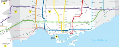
In the past few years, I’ve come across a microculture of mass-transit afficionados. Some go as far as to create “fantasy” transit maps, particularly of subways or light rail::

I think this stuff needs to get plugged into a Sim-City-like environment, but like any abstraction, it’s only as good as its assumptions. My utopian vision of Toronto is one with concentrated development along corridors and with a direct connection to Pearson {Airport}. My idea was a line that went from Pearson to downtown, following Queen in the downtown core, and eventually looping back up to the Bloor-Danforth line.
Any thoughts on your town/city? Is it walkable? Does it matter?
Twitterversion:: WalkableCity-#Toronto,Transit& CarCulture.Can TO dvelpmnt be shaped,creating vibrant communities sans cars? http://url.ie/1zuk #ThickCulture @Prof_K

Comments 3
Mary Soderstrom — July 12, 2009
For more on grids, you might find this post on Urbanphoto interesting: http://www.urbanphoto.net/blog/2009/07/12/before-the-grid/ I was working on it when I got Google alert about this post: I hope you find The Walkable City interesting.
Mary
marcel — July 13, 2009
I'm lucky to be living pretty much at the centre of Vancouver and walk to work from my place near 12th & Main to Coal Harbour. The walk takes me about 40mins, as I like to dawdle. It's very easy from my home to get anywhere I want in the city by walking and I often go out looking for new areas to explore on foot. My partner, who used to live in Gastown, loves being in a neighbourhood that is more conducive to walking.
I think having the luxury of being able to walk in your city is valuable. One of the things my partner has mentioned is how you find so many neat little things that you wouldn't normally come across when you are stuck in a car or bus. A great way to learn about more of these little treasures is to take walking tours, which will give you a better sense of the neighbourhood's history as well as partaking in the annual jane's walk that happen in many cities across North America including Toronto. If you happen to be in Toronto next year, during the first week of May, I highly recommend taking in a few of these. I've yet to do one that I've not been fully satisfied with. I might even lead one of my own next year.
Mary Soderstrom — July 16, 2009
Actually there were Jane's Walks in more than 30 Canadian cities this May. I led one in my neighborhood and it was great fun. Be sure to look for one near you next spring--or, better yet, organize one!
Here's the link:http://www.janeswalk.net/
Mary