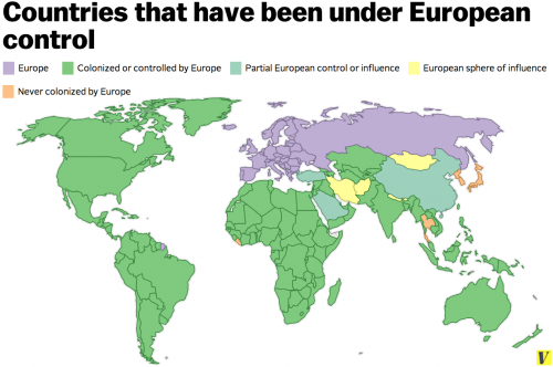
This is a map of the countries Europe colonized, controlled, or influenced between 1500 and 1960. The purple is Europe. The orange countries are ones never under European rule. Almost the entire rest of the map — all the green, blue, and yellow — were dominated by Europe to some extent. “Influenced” is pretty much a euphemism and often not all that different than outright domination.
Max Fisher, writing at Vox, summarizes:
There are only four countries that escaped European colonialism completely. Japan and Korea successfully staved off European domination, in part due to their strength and diplomacy, their isolationist policies, and perhaps their distance. Thailand was spared when the British and French Empires decided to let it remained independent as a buffer between British-controlled Burma and French Indochina…
Then there is Liberia, which European powers spared because the United States backed the Liberian state, which was established in the early 1800s by freed American slaves who had decided to move to Africa.
More details and discussion at here.
Lisa Wade, PhD is an Associate Professor at Tulane University. She is the author of American Hookup, a book about college sexual culture; a textbook about gender; and a forthcoming introductory text: Terrible Magnificent Sociology. You can follow her on Twitter and Instagram.

Comments 22
Jones — March 21, 2015
What about Tonga?
Bernardo — March 21, 2015
While it nicely brings across one specific point, I think the map is much too unspecific to instill any real sense of history. Starting from the problem of projecting today's countries' borders back to the year 1500, it operates with extremely broad spatial and temporal categories.
Whether one can simply count the whole of Russia (which had to be conquered in a long colonisation process before becoming the huge unified landmass represented on the map) to "Europe" is debatable. Many countries in Europe have never been colonial powers, some (like Switzerland and Sweden) have nevertheless profited in economic ways, many European countries have actually been colonised themselves (Poland and Ireland come to mind, but there are many more).
Neither the Habsburg Empire (which colonised much of Eastern Europe) nor the Ottoman Empire (which extended over North Africa, parts of South Eastern Europe, and the Middle East), nor the Chinese Empire are represented in any way. Nor are the Mughal empires, the multiple smaller African empires that existed until well into the 1800s, or the history of Arab influence on the east coast of Africa. It also doesn't show the US's formal and informal colonies.
Neither does the map show that the regions that were under European colonial rule or influence in the Middle East and in parts of Southeast Asia had been under imperial rule for quite some time when the Europeans came and took over.
The map also doesn't tell you that in Africa, formal colonisation was a relatively short period in history, and it would be difficult to represent the much longer and more complicated history of the Atlantic and Indian ocean slave trades that had little to do with political influence, but a lot with economic systems.
It also doesn't differentiate the multiple forms of colonial rule, from incorporaing a region into the "motherland" to administrating a country under the mandate of the League of Nations, which came with a host of different political and legal systems that gave local elites very different options.
Thus, I think the map gives the wrong impression that for a long period, "Europe" controlled the world, which is easily refutable, doesn't give us any real understanding of the role of colonialism in history, and operates with problematic, extremely vague categories. As a teacher of African history, I have to say I wouldn't use this in the classroom.
Now — March 22, 2015
Fcking white people , I want to do a thesis or a phd to study the origins of "why white people do the dumbest possible things in life "
Alex — March 22, 2015
When was Caucasus countries controlled by Europe?
Chart of the Week: The Breadth of European Colonization - Treat Them Better — March 22, 2015
[…] Chart of the Week: The Breadth of European Colonization […]
Angel — March 22, 2015
the author is too idiot or drunk, when was Ethiopia colonized and by whom? you need to re-check your facts!
Rutger Mooy — March 22, 2015
That's 5 countries: Thailand, Japan, N Korea, S Korea, Liberia.
Chart of the Week: The Breadth of European Colonization » Antropologia Masterra — March 22, 2015
[…] (View original at http://thesocietypages.org/socimages) […]
Now — March 22, 2015
the damn fcuking Europeans Fcuked up the whole world.... 3/4th of the conflicts in today's world are due to the damn European and the Russians !
The proof can still be seen - UK, USA, France continue to bomb countries for no good reason at all !
Shanning — February 15, 2021
The map is misleading.
If some coastal cities of a country were partially colonized, the entire country got marked as partially colonized(for example China). That is misrepresenting data. Also, the shape of Australia indicates that the map is using the cylindrical equal-area projection world map. But they erased the curving lines of latitudes(you can read about the Gall–Peters projection and the equal-area projection). That is inaccurate.
The data visualization designer of this map is either incompetent or overtly Eurocentric. I can't decide which one. I'm pressured by the facts to believe he/she is both.